Categories
Historic Sites

PMN leaves the Inquirer Building: a look back in pictures

A 2006 shot of the Philadelphia Inquirer Building. Photo Credit: Medvedenko

For decades, Philadelphians have picked up two of the most prominent city newspapers — the Inquirer and the Daily News — knowing that the lens through which they learned about Philadelphia, good and bad, was secure in the imposing, palatial Inquirer building on North Broad Street.

The building and the publishing company have weathered alterations over the years. But as of last week, a more jarring change impacted workers at Philadelphia Media Network, as they settled into a new office at the Strawbridge and Clothier building at the bustling corner of 8th and Market.

The new space is roughly one fifth the size of PMN’s former habitat, according to numbers reported by the New York Times. It’s unclear what the future holds for the publishing company, but the storied history of its home is certain.

In honor of the move and the future, what follows is a gallery of photos depicting the Inquire building through the years. Best of luck to the two daily newspapers and staff.

Categories
Historic Sites

The archaeological investigation at the West Shipyard is open to the public Friday


A 1914 picture of Pier 19 possibly taken from the West Shipyard
lot undergoing excavation.

When someone says the words “archaeological dig,” ancient Greece, Egypt or Rome tend to come to mind along with visions of buried treasure and mummies galore.

But Philadelphia has started its own archaeological excavation led by the John Milner Associates along with the Delaware River Waterfront Corporation who have collectively started digging up a thatch of the waterfront at Columbus and Vine, across from Pier 19, in search of the remains of the West Shipyard.

The crew, of course, is not hunting for mummies. They are hoping to discover evidence of the ship building and repairing business that a man named James West owned from 1676 to 1701 — reportedly pre-dating the arrival of William Penn — according to the West Shipyard blog.

The slipway being prepared for excavation is commonly referred to as the Hertz Lot after a Hertz Rental Car opened a location there in 1969 and was listed as the first archaeological site on the Philadelphia Register of Historic Places, according to the Philadelphia Archaeological Forum.

Today the spot in question could not be more unassuming as a battered old parking lot across from the beer, fries, and gameland that is Dave and Busters.

In a recent story on the dig at Hidden City, Harry Kyriakodis, an expert on Philadelphia’s waterfront, describes the original use of the West Shipyard this way:

“In the days before dry docks, sailing ships needing repair would be dragged up slipways (launching ramps) to enable repairs to be made. New vessels, needless to say, were also built on such ramps. A ropewalk (a long straight narrow lane where rope was made) was immediately north of the West Shipyard.”

Kyriakodis reports that West’s son took over after his father’s death in 1701, turning the locale into “miniature ‘company town,’ complete with shops and inns to support its workers,” but advancements in shipbuilding technology eventually outgrew the small shipyard.

Of course the goal is not simply to unearth remains. The study is part of the DRWC’s larger stated plans to redevelop and preserve Philalphia’s once lively, but now underutilized waterfront.

The archaeological dig began on July 16 and is open to the public Friday afternoon, July 20, from 1:00pm to 3:00pm, but you can also click here to arrange an appointment to survey the dig during the week of July 23-27.

Update: An additional public tour time has been added due to popular demand. The site will also be open to the public on Tuesday, July 24, from 5-7pm.

Categories
Historic Sites

Sister Cities: the history of a newly restored piece of Logan Square

A recent aerial view of Sister Cities park.
Photo Credit: Marc Morfei

By Yael Borofsky for PhillyHistory.org

Sister Cities park, reopened this May, is a beautiful homage to urban revitalization, combining the charming with the whimsical in a series of landmarks signifying Philadelphia’s ten sister cities: a cafe, a boat pond, and other small wonders that draw people to Ben Franklin Parkway where the park is situated.

But don’t let the newness or the cuteness distract from the fact that there are a couple of odd things behind Sister Cities park.

For one, no one seems to know exactly why Tel Aviv and Florence became Philadelphia’s first two sister cities — Florence in 1964 and Tel Aviv in 1967.

Nancy Gilboy, president of Sister Cities administrative body, the Philadelphia International Visitors Council (IVC), says that at the time, the induction of Sister Cities was all about relationships.

“It usually comes about when somebody of prominence in each city meets and they see there are synergies between the two cities,” Gilboy explained, adding that program was started in the 1950s by President Eisenhower in an effort to bridge cultural divides.

But Gilboy said she couldn’t be sure who was directly responsible for the relationship with both the Israeli and the Italian city, aside from Mayor James Tate who formally invited both cities to participate in the program.


An aerial view of Sister Cities Plaza from 1972.

This archived news article documenting the designation of Philadelphia and Tel Aviv as Sister Cities on April 24, 1967 suggests that one connection between the two cities is that both were sites of independence:

“The ceremonies were held after Philadelphia Mayor James Tate sent a message to Mordechai Namir, Mayor of Tel Aviv, noting that the declaration was being issued on the eve of Passover, “Feast of Freedom” and pointed out that both cities have been sites of declarations — the U.S. Declaration of Independence on July 4, 1776 in Philadelphia, and the Israeli declaration of independence on May 14, 1948 in Tel Aviv.”

One theory commonly put forward is that Philadelphia’s significant Italian and Jewish immigrant populations had something to do with the inter-city connections.

Other oddities about Sister Cities have more to do with the park, before the city had any sisters to honor.

Despite it’s relatively small size — it’s just one tiny chunk of Logan Square — the site has an rich history that includes serving as a grave site for various religious organizations and health institutions, a gallows, and a potter’s field. When Center City District began working to revamp the site, it knew that it and its partners would have to tread lightly, said Vice President of Planning at Center City District Nancy Goldenberg.

Still, when the early stages of park remodeling in 2010 revealed 60 orderly grave sites along the 18th Street border of the park, CCD had to revise many of its plans, including the placement of geothermal wells, in order to avoid disturbing them further.

Goldenburg said that research suggests the graves belonged to the First Reform Church in Old City, who apparently also used the land as burial grounds.

But if bones, hangings, and merchants seem a bizarre mix for a site that now attracts many small children, the location has even older less consistent roots in the Civil War. The spot was used to site the Great Sanitary Fair (or Great Central Fair) of 1864. The multi-week event was designed by the Sanitary Committee, a federal agency, to gather proceeds to fund care and supplies for the Union soldiers, said Goldenberg.

“The fair actually took up all of Logan Square but coincidentally, the fair had a children’s playground area and that was actually located where Sister Cities park is today,” Goldenberg said. “And of course we have a children’s garden in our park so that was really quite ironic.”

The Sanitary Committee, the precursor to the American Red Cross, traveled around the country holding these fairs to drum up wartime support, but Goldenberg says Philadelphia’s Fair was the only one honored by the attendance of President Abraham Lincoln. According to an archived Philadelphia Ledger article from July 1, 1864, the organizers culled about $7,000 in entrance fees, or about $102,000 by today’s standards.

Thanks to the remodeling, the park contains numerous reminders of its sordid past, but as you walk through the modernized form of Sister Cities park it’s worth remembering that things are rarely what they seem.

Categories
Historic Sites

What’s Preserved and What’s Forgotten: The Louis Bergdoll and Sons Brewing Company Grain Elevator

City Park Brewery in 1948, after the brewery shut down,
from Pennsylvania Ave at 29th and Parrish.

The looming brick complex pictured left, situated at 29th and Parrish, is the brainchild of Otto C. Wolf, a Philadelphia staple in brewery architecture. Louis Bergdoll had the complex built to house his City Park Brewery in 1856 and it produced a popular lager for the city until Prohibition in 1920.

“It’s the crowning achievement of Wolf,” said beer historian Rich Wagner of the brilliant buildings located just north of the Art Museum. Today, the complex is known as The Brewery, a condominium named in homage to the Louis Bergdoll and Sons Brewing Company’s City Park Brewery.

Though we’ll never know for sure, City Park Brewery reportedly turned out one of the best tasting beers of its day.

Despite attempts by the Bergdoll family after Prohibition was repealed in 1933, the brewery was never fully operational again. Its demise isn’t unlike the narrative many of the Brewerytown breweries, including those along Philadelphia’s beer-laden Girard Ave., which shuttered for good.

“The brewmaster shot himself in the basement of the brewery,” Wagner says the story goes. “He was the brains of the outfit and when he blew his out that left them with nothing.”

It’s not the only bout of bad luck associated with the Bergdoll name, according to this 1924 Evening Tribune article about the curse associated with the original Bergdoll’s widow and surviving family.

Wagner, who is the author of the book Philadelphia Beer: A Heady History of Brewing in the Cradle of Liberty, (reviewed by Daily News beer columnist Joe Sixpack here) says it is “the most outstanding example of brewery preservation in the state” because it preserves what Wagner says was the “most beautiful brewery complex when it was in business” — as well as the memory of a once dominant brewery.

“Industry buildings can tend to be utilitarian,” Wagner said. “But in this day and age the brewers were bombastic. They wanted to have the biggest castle on the block.”

THE BREWERY TODAY


The grain elevator in 1932 at 29th and Pennsylvania Ave.

The existence of the Brewery Condominium, as its been known since it was revamped in the 1980s — a complex made of three buildings eponymously dubbed The Main House, The Brewery House, and The Ice House — tells only half of the Bergdoll Brewing Company’s story.

The other half can be told by what’s not been preserved: the grain elevator and malt house.

Ironically, the exclusion is emblematic of the fate of Philadelphia’s malting industry, which helped define Philadelphia beer brewing culture in the years before prohibition.

Malting is a process by which barley is turned into malt, a critical ingredient for brewing beer. The process involves allowing large quantities of barley, fresh from the fields, to sprout before being roasted, Wagner explained.

The malting industry in Philadelphia got its start with Anthony Morris in 1687, whose firm, the Perot Malting Co., had an office in Philadelphia into the 1960s, Wagner said. Most other maltsters weren’t so lucky after Prohibition dried up most of their customers.

The Louis Bergdoll and Sons Brewing Company, like quite a few other breweries in the city, produced its own malt. But Wagner says that of the approximately 20 malt houses in the city at the time, none operate today, as far as he knows.

This grain elevator (pictured left) marks a point where the barley that would become the malt for City Park Brewery’s beer entered the city, probably from Toronto, Wagner said. It’s also where the extra malted barley that wasn’t used at the brewery was shipped out.

According to the Hexamer map below, the Bergdoll Brewing Co. built the grain elevator in the early 1890s, not long before Louis Bergdoll passed away.

Large shipments of barley would be unloaded off railcars into the building and sent, probably in buckets, Wagner said, via conveyor system to the malting house. Then the brewed beer, high in demand, could make the block and a half trip back to the grain elevator for storage and eventual shipment out to thirsty beer drinkers.

The grain elevator was across the street but connected to the brewery’s campus, almost like a sort of strange external organ pumping barley around the complex and ultimately taking up the final, bubbling product and pushing it out to the world.

Wagner estimates that the grain elevator and malting house could have helped Louis Bergdoll and Sons Brewing Company malt about 200,000 bushels of barley a year.

Why wasn’t this critical and outward facing piece of the brewery’s architecture preserved?

Wagner thinks that between the building materials and its location immediately adjacent to the rail line, the grain elevator may have been too difficult to preserve.

If you look closely at this Hexamer map (close-up below) from 1892, you can see that the building was located directly on the rail tracks and made of cement, brick, corrugated iron, and a metal roof. It had “double flooring boards … with layer of Asbestos between,” according to the itemized account on the map.

Not exactly the ideal foundation and location for a condominium complex, particularly not “compared to those beautiful buildings of the brewery that are built to withstand the weight of tanks and tanks full of beer,” Wagner noted.

Still, the grain elevator’s decay reminds Philadelphia of its beer-drenched roots as much as the beautifully redone brewery residential complex just across 29th Street.

Map courtesy of Greater Philadelphia GeoHistory Network. It can be seen in greater detail here.

Categories
Historic Sites Neighborhoods Snapshots of History Uncategorized

William H. Shoemaker Junior High School

William H. Shoemaker Junior High School under construction, 7/1/1926.
William H. Shoemaker Junior High School under construction, 8/3/1926.
William H. Shoemaker Junior High School under construction, 12/2/1926.
William H. Shoemaker Junior High School under construction, 12/29/1926.
William H. Shoemaker Junior High School completed, 6/28/1927.

“A school system that is not costing a great deal these days is not worth a great deal.”

– The Centennial Anniversary of the Public Schools of Philadelphia: A Recapitulation, March 1918.


During the 18th and early 19th centuries, Philadelphia’s Quaker schools (Friends Select), and its Protestant church schools (Episcopal Academy) provided rigorous education for the sons and daughters of the well-to-do.  In the meantime, the Roman Catholic archdiocese set up an extensive network of parochial schools. Sectarian private schools not only provided community and opportunity, but also reinforced cultural and class identity.

Although the city’s ethnic and religious communities were very good at taking care of “their own,” public education for all proved an uphill struggle for civic leaders. Girard College, a private institution, did provide education to the disadvantaged, provided they were “poor, white, male orphans.” Central High School, founded in 1836 and known as the “People’s College,” provided quality, non-sectarian secondary education for those who met the admission requirements. Some students, like future artist Thomas Eakins, were from middle class families.  Others, such as future pharmaceutical magnate Dr. Albert Barnes, came from abject poverty.  Girls High School, formed along similar lines, followed in 1848.

Although the Philadelphia School Board was formalized in 1818 (with Roberts Vaux as its first superintendent), it was not until the early twentieth century that the city implemented the comprehensive K-12 public education system we know today. By 1918, Philadelphia’s public school system boasted 230,000 pupils taught by 6,300 teachers, housed in over 300 educational structures.*   That same year, school superintendent Garber chastised those who held the view that “there are two classes of society, a higher and a lower, and that it is a mistake to endeavor to break down the barrier between the two.”** Education, leaders like Garber argued, was the great leveler of American society, allowing those born in modest circumstances to rise into the ranks of the middle class and beyond. Philadelphia’s public school system, he concluded, should be the “inveterate foe of ignorance, poverty, disease, crime, and all forms of human waste and neglect…”***

During the booming 1920s, the School Board shifted into high-gear and built two co-ed high schools in West Philadelphia: West Philadelphia High School and Overbrook High School. The School District also started a revolutionary, three-year junior high school program that prepared grammar school graduates for the rigors of secondary education.   Among these new schools was William H. Shoemaker Junior High School, located at 5301 Media Street in the Haddington-Carroll Park section of West Philadelphia. In contrast to adjacent, affluent Overbrook, this was a middle and working class district which grew up along the Lancaster Avenue trolley tracks.  Originally a sleepy country village, Haddington exploded following construction of the Market Street Elevated rail line to the south. The majority of Haddington-Carroll Park’s residents lived in modest, two-story brick rowhouses.  Family stores and manufacturing operations sprouted up along Lancaster Avenue. According to Margaret S. Marsh’s study of the area’s early twentieth century demographics, the mostly-white residents of Haddington-Carroll Park were clerks, bookkeepers, teachers, and small businessmen.  As in neighboring Parkside, there was also a significant Jewish population. The proliferation of clubs and fraternal organizations created, as Marsh wrote, “‘instant’ community for the thousands of newcomers,” and “assured potential members of association with people of similar background.”**** At the same time, a growing number of African-Americans from the Deep South migrated to Haddington in search of work and opportunity. Not surprisingly, they often faced hostility and discrimination from neighbors and employers.*****

As a counterweight to social and racial segregation, schools like William H. Shoemaker Junior High (named for a prominent judge) provided a forum where various ethnic and religious groups could come together for the common purpose of education. Construction began in 1925 and was completed two years later.  It was most likely the work of Irwin T. Catharine, principal architect for the Philadelphia School system between 1918 and 1937.******   Architecturally, it bore a strong resemblance to West Philadelphia and Overbrook High, with its neo-Gothic detailing, pointed-arch windows, and spire-topped towers.  Inside, the school boasted a tiled grand staircase and a two story Georgian auditorium. Hallways were wide and spacious, classrooms steam-heated and lit by large windows. Shoemaker’s appearance may have been an homage to the “collegiate Gothic” of nearby Penn and Princeton, thus giving the middle and working class children of Haddington-Carroll Park a taste of the grandeur previously reserved for the privileged.

A photograph of the first graduating class of William H. Shoemaker Junior High School (1929) gives a rare glimpse into Haddington-Carroll Park’s past.  The children are all in uniform: coats and ties for boys and blouses for girls. Not surprisingly, most of the children are white, but there are a few African-Americans standing in the rows. Looking at the area demographics at the time, it is clear that Shoemaker Junior High was sandwiched between two increasingly segregated neighborhoods. In 1930, Southern Haddington was over 43% non-white, a trend that would accelerate during the Great Depression.  Upper Haddington-Lower Overbrook, by contrast, was only 7.5% nonwhite.*******

First graduating class of William H. Shoemaker Junior High School. Courtesy of Shoemaker Campus — Mastery Charter Schools.

After World War II, institutionalized “red-lining” by insurance companies and “block-busting” by realtors, compounded by the departure of industry, transformed the area around Shoemaker into a segregated slum, with few economic opportunities for its almost entirely African-American population.  Family businesses on Lancaster Avenue were shuttered and houses destroyed by neglect or arson, a trend repeated in urban areas throughout the nation. By the 1980s, a drug epidemic turned the streets surrounding the school into a war zone.   The structure itself crumbled from deferred maintenance, and the Philadelphia Inquirer rated it as the second most dangerous junior high school in the city.********

In 2006, Mastery Charter Schools took over management of the school. Renamed Mastery – Shoemaker Campus, the school has staged a remarkable turnaround. According to Mastery’s website, violent crime has dropped 90%, and 100% of its graduates have been accepted to institutions of higher learning.*********  Most of the building has been completely renovated and modernized, and is now completely air conditioned.

The un-renovated part of the school, about 30% of the building according to director of operations Dan Bell, is sealed off.  Plaster dust coats chairs and desks. An old piano sits in the deserted music room. Mountains of old books cascade out of a storage closet. Mean-spirited graffiti is scrawled on the plaster walls.

While most of the school bustles with life, energy, and the promise of the future, these silent spaces bear silent witness to the grandeur, optimism, sadness, and pain of Shoemaker’s past.

Special thanks to Robert S. Richard (City Year) and Daniel Bell (Shoemaker Campus — Mastery Charter Schools) for making this article possible. 

The old cafeteria. Photograph by Steven B. Ujifusa.
The auditorium, in use since 1927. Photograph by Steven B. Ujifusa.
A piano sits in the former music room. Photograph by Steven B. Ujifusa

*John P. Garber, The Centennial Anniversary of the Public Schools of Philadelphia: A Recapitulation (Philadelphia: Philadelphia Trades School, March 1918), p.15. Collection of the Free Library of Philadelphia, Cities P53-562-b.

**John P. Garber, The Centennial Anniversary of the Public Schools of Philadelphia: A Recapitulation (Philadelphia: Philadelphia Trades School, March 1918), pp.8-9. Collection of the Free Library of Philadelphia, Cities P53-562-b.

***John P. Garber, The Centennial Anniversary of the Public Schools of Philadelphia: A Recapitulation (Philadelphia: Philadelphia Trades School, March 1918), p.16. Collection of the Free Library of Philadelphia, Cities P53-562-b.

****”Philadelphia Public Schools Thematic Resources,” National Register for Historic Places Inventory — Nomination Form. December 4, 1986.

*****Margaret S. Marsh, “The Impact of the Market Street ‘El’ on Northern West Philadelphia: Environmental Change and Social Transformation, 1900-1930,” from William W. Cutler III and Howard Gillette Jr., The Divided Metropolis: Social and Spatial Dimensions of Philadelphia, 1800-1975 (Hartford, CT: Greenwood Press, 1980), p. 174.

******Margaret S. Marsh, “The Impact of the Market Street ‘El’ on Northern West Philadelphia: Environmental Change and Social Transformation, 1900-1930,” from William W. Cutler III and Howard Gillette Jr., The Divided Metropolis: Social and Spatial Dimensions of Philadelphia, 1800-1975 (Hartford, CT: Greenwood Press, 1980), p. 182.

******* Margaret S. Marsh, “The Impact of the Market Street ‘El’ on Northern West Philadelphia: Environmental Change and Social Transformation, 1900-1930,” from William W. Cutler III and Howard Gillette Jr., The Divided Metropolis: Social and Spatial Dimensions of Philadelphia, 1800-1975 (Hartford, CT: Greenwood Press, 1980), p. 184.

********Shoemaker Campus Information, http://www.masterycharter.org/schools/shoemaker-campus/about-shoemaker.html

*********Shoemaker Campus Information, http://www.masterycharter.org/schools/shoemaker-campus/about-shoemaker.html


Categories
Historic Sites Neighborhoods Uncategorized

The Germantown Cricket Club

Germantown Cricket Club, c.1900.

Hidden behind a high brick wall stands a forgotten masterpiece of American architecture, designed by the same firm responsible for New York’s Pennsylvania Station and the Boston Public Library.

The Germantown Cricket Club, a National Historic Landmark, is one of the few surviving structures in Philadelphia designed by McKim Mead & White.

It is a strange juxtaposition, indeed: one of the nation’s oldest country clubs situated in an dense, inner-city environment.

When Germantown Cricket Club was built in the 1890s, the surrounding area was a fashionable suburban district, popular with commuters and summer residents seeking clean air and green space.  What better place for traditional country sports?

Cricket is, of course, a British import, and an ancestor of modern American baseball. During the mid-19th century, Philadelphia was an American mecca of this quintessentially British game, and it’s “elevens” were competitive with the best teams from the other side of the pond. One of Philadelphia’s greatest cricketers was Germantown founder William Rotch Wister (1827-1911), who actively promoted the game to a broad American audience after watching English immigrant millworkers play it during their precious off-hours.  He was also the uncle (and father-in-law…) of novelist Owen Wister.*  Wister, along with a group of well-connected Philadelphia sportsmen, founded the Germantown Cricket Club in 1854.  The club first played on a crease in the Nicetown section of the city — conveniently close to the Wister family compound — until 1891, when the current clubhouse was constructed on Manheim Street.

The clubhouse is most likely the vision of Stanford White, the most creative and visionary of the McKim Mead & White partners.** White’s residential architecture, especially in New York, tended towards the theatrical, with plenty of rich materials and ornamentation.  He also had a hand in designing resort structures such as The Casino in Newport, Rhode Island, which used Japanese architecture for inspiration.  But perhaps in the spirit of appeasing his conservative Philadelphia patrons, White tempered his architectural language, giving Wister and his friends a staid, symmetrical, red-brick Georgian composition that harkened back to Philadelphia landmarks such as Independence Hall and Christ Church.

In the best Beaux Arts tradition, White created an efficient floor plan that revolved around a central axis, in this case a long hallway that ran the entire length of the first floor.  Since the club would be most heavily used in the warm-weather months, creating enough cross-ventilation in the fierce Philadelphia heat was a real design challenge.  White’s response was to place a double-tiered veranda in the center of the building. This feature not only allowed fresh air to circulate throughout the main public rooms (including the barrel -vaulted ballroom on the second floor), but gave members a shaded viewing stand for watching the matches on the crease below.  Brightly-colored striped window awnings, fixtures on homes throughout the city during the summer, also helped keep the building cool.

At Germantown, Wister’s cricket boosterism worked for a while — in the first decade of the twentieth century, thousands of people took the train out to the suburbs to watch the matches. Yet there were some fundamental problems with American cricket, especially as the pace of life quickened with industrialization and corporate consolidation.  First, it was a slow game, and matches could last for days.   Few spectators, let alone players, had the time to devote to such a leisurely sport.   Second, women were excluded by custom from elevens teams.  Above all, more Americans found cricket just plain boring, especially compared to collegiate football and nascent professional baseball teams.

By the 1910s, a new sport took over the grass creases of Germantown Cricket: lawn tennis. It not only provided vigorous exercise in a short period of time, but also allowed female participation.  It was at Germantown Cricket that William T. “Bill” Tilden II honed his skills as a boy and became America’s greatest tennis player. The tennis craze even spread to the White House.  President Theodore Roosevelt, America’s greatest exponent of physical fitness in the early 1900s, frequently played with a group of advisors that came to be known as the “Tennis Cabinet.”  Yet as an advocate of contact sports such as football and jujitsu, Roosevelt adamantly refused to be photographed in what he considered to be effete tennis whites.

During the middle of the twentieth century, cricket declined as Philadelphia became a tennis mecca. The city produced not just Bill Tilden, but also Wimbleton champion E. Victor Seixas Jr.  In the early 1920s, Germantown hosted the U.S. Open.  So great was Philadelphia’s place in tennis lore that Penn sociologist E. Digby Baltzell wrote an entire book about it — Sporting Gentlemen — in which the author lamented the supplanting of amateur players by professionals.***

Today, Germantown Cricket has been carefully restored and modernized, and its membership has diversified considerably since the days of Tilden.  It  now boasts programs not just in tennis and squash, but also an outdoor swimming pool and bowling alley.  And occasionally, the tennis nets are removed and two sets of “elevens” engage in a cricket match on the close-cropped grass courts.

Yet Philadelphia’s most active cricket field is not surrounded by a high brick wall, but is open to all.  During the summer, on the fields in Fairmount Park, teams composed largely of immigrants from the Caribbean and Pakistan play every weekend, keeping a distinctly Philadelphia tradition alive and well.

*Obituary for William Rotch Wister, Wednesday, August 23, 1911: “The Philadelphia Press.”  The former William Rotch Wister estate is now the site of La Salle University.

**In 1906, Stanford White was shot to death by Harry K. Thaw on the rooftop garden of New York’s Madison Square Garden.  Thaw’s wife Evelyn Nesbit had once been White’s mistress.  The murder (and all its salacious details) was dubbed the “Crime of the Century.”

***E. Digby Baltzell was godfather to Whit Stillman, director of Metropolitan, The Last Days of Disco, Barcelona, and Damsels in Distress.

1893 watercolor of the Germantown Cricket Club by A.L. Church. Image: Wikipedia Commons
Bill Tilden. Image: Wikipedia Commons

William Rutherford Mead, Charles F. McKim, and Stanford White.  Image: www.fineartamerica.com

Categories
Historic Sites Uncategorized

Cliveden: An Historic Germantown Mansion Redefines its Mission


Purchase Photo View Nearby Photos
Photograph of Cliveden taken by James McClees in
February, 1857.

In 2008, three men made a pilgrimage from Philadelphia to Frisby’s Prime Choice plantation in Cecil County, Maryland. The first was Phillip Seitz, curator of the Cliveden estate, a National Trust historic site in Germantown and the long-time home of the Chew family.  The second was John T. Chew Jr., a member of Cliveden’s board and a descendant of the original owner.  The third was John Reese, chef and former employee at Cliveden, who is captivated by the untold stories of those who lived and worked at the estate.

What prompted their visit were discoveries in the Chew family papers, recently archived by the Historical Society of Pennsylvania. These documents not only provide a rich record of seven generations of one of Philadelphia’s most eminent legal families, but also names and descriptions of the slaves that worked the various Chew plantations two centuries ago.

After driving through endless fields of wheat, Reese asked if they were getting close to Frisby’s Prime Choice. Seitz responded that they had been driving through the former Chew plantation for the past 20 minutes.  According to Chew family records, about seventy enslaved African-Americans farmed over 1,000 acres of land during the late 18th century.

After visiting the plantation house, they drove 40 minutes due east to the river landing, where two hundred years ago, the slaves loaded the produce they harvested by hand onto waiting ships.

As he stood on the river bank, Reese was convinced he could see ghosts of these men rolling barrels down to the dock.

Chew was deeply moved as he watched Reese tear up. “When I saw John visibly moved, looking out over fields of long grass, stretching to the horizon,” he remembered, “I was overcome with a deep sadness for enslaved people, and their plight. John – and the moment – helped me feel in a way I never had before the sorrow, the anger, and the frustration of people held against their will.”

* * * *


Purchase Photo View Nearby Photos
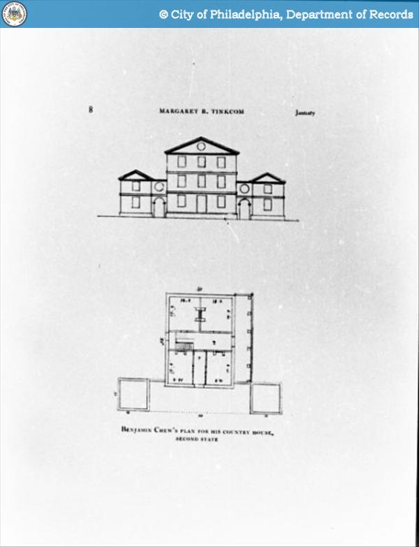
Early sketch of plans for Cliveden c.1760, possibly drawn
by master carpenter Jacob Knor and Benjamin Chew.

Cliveden’s original owner, Benjamin Chew (1722-1810), was the son of Maryland Quakers.  He received his training in London’s Middle Temple, making him one of the most highly-trained lawyers in the Colonies. The Penn family recognized his talent, and he became their principal legal advisor.  Unlike other lawyers of the time, who had a penchant for flowery and wordy opinions, Chew’s writing was defined by brevity and clarity.[i] Chew’s crowning appointment was Chief Justice of the Supreme Court of the Province of Pennsylvania – he was the last man to hold that position before America declared independence from Great Britain. In addition to his legal prowess, Chew was a shrewd land speculator. Much of the wealth that supported the family’s lavish Philadelphia lifestyle flowed from several tobacco and wheat plantations in Maryland and Delaware.

In 1767, Benjamin Chew completed a summer retreat in Germantown he called Cliveden, built in the highest Georgian style.   The estate had manicured gardens, wooded groves, and several outbuildings, including a large carriage house.  The inside of the stone mansion boasted elaborate woodwork and furnishings imported from England.  Although he possessed no architectural training, it appears that Chew had a hand in designing the house.


Purchase Photo View Nearby Photos
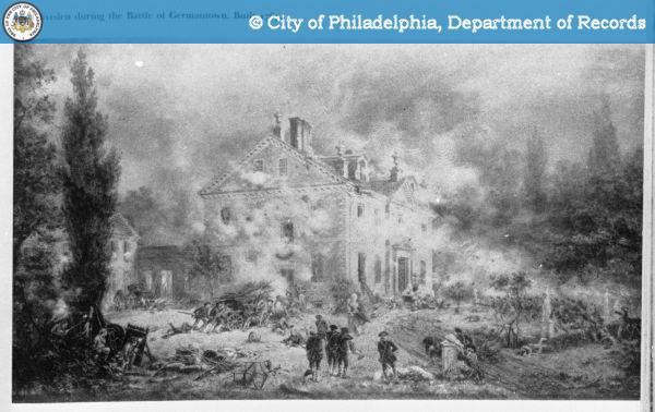
Cliveden under assault by Washington’s troops
during the Battle of Germantown, 1777.

During the American Revolution, the pacifist Chew sided with the Crown and his principal clients, the Penn family. As a result, the Continental Congress placed him under house arrest in New Jersey.  After the Revolution, Chew returned to his successful legal practice. Despite questions about his loyalty, George Washington and John Adams had immense respect for him, and friendships such as these allowed Chew to reclaim his position in the Philadelphia power structure. Back on his feet, Chew repurchased and restored his beloved summer house, badly damaged by artillery fire during the 1777 Battle of Germantown.

The Chews continued to own Cliveden until 1972, when they donated the house and its contents to the National Trust for Historic Preservation. Today, the house is filled with antiques and family heirlooms, some dating all the way back to the time of Benjamin Chew.  But hidden away in Cliveden’s nooks and crannies were thousands of pages of letters, journals, account books, and other correspondence that the family maintained over the past two centuries.  Like the Adamses of Massachusetts, the Chews kept everything they wrote, making the collection a boon for American historians. These documents brought the human story of the Chews back to life — they mourned the deaths of loved ones, squabbled over inheritances, and kept track of their expenditures.

The papers also revealed in vivid detail about how much of the Chew’s early wealth had come from slavery. Correspondence between the Chews and their overseers demonstrated that the slaves on their plantations were far from compliant. During the Revolution, when Benjamin Chew was briefly imprisoned, a number of his slaves ran away.  Those that remained on the plantations developed their own unwritten social and work rules.  One time, the overseer at one of these plantations wrote Benjamin Chew pleading for back-up. Two slaves named Aaron and Jim had badly beaten him after his brutal treatment of the work force during the harvest season.  It took three weeks for Chew to send reinforcements and bring order to the plantation. Aaron and Jim submitted to the whipping, sacrificing themselves for the good of their fellow slaves.
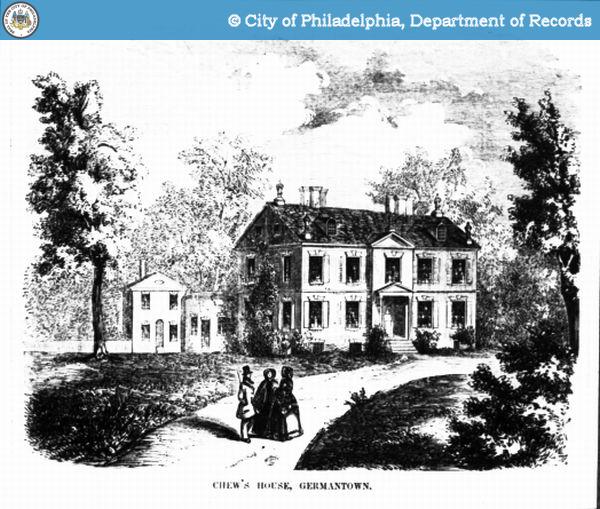

Purchase Photo View Nearby Photos
Illustration of Cliveden c.1850.

After the American Revolution, Pennsylvania abolished slavery, but the Chews continued to hold onto their properties in the slave states of Maryland and Delaware.  But by the early nineteenth century, the Chews saw the writing on the wall. They decided to divest themselves of their family plantations and put their capital in Pennsylvania industry and land speculation. Benjamin Jr., who served as his father’s principal plantation manager, was put in charge of this task for his extended family.  In 1809, Benjamin Jr. traveled south to settle the estate of an uncle who had died in debt.  In his letters home, he was clearly torn between family financial obligation and the fate of his uncle’s slaves, who had been denied the freedom their master had promised them.

“I found it absolutely necessary to return to this Place which I did last Evening and tomorrow sell off the Remains of any poor Uncle John’s Remnants,” Benjamin Jr. wrote his father on November 15, 1809. “I have fortunately succeeded in providing Homes for all but 7 or 8 of the Black People—a Task indeed of the most conflicting Difficulty—I have I believe succeeded in giving the poor Creatures as much Satisfaction as they could have, under a disappointment in not having their Freedom bequeathed to them—they generally thank me for what I have done for them—the Stock of all kinds I have also sold except what is necessary to retain to secure the Crops.”[ii]

* * * *

The Chew family papers — donated by the family to the Historical Society of Pennsylvania in 1982 — were opened to the public last year.  A grant from the National Endowment for the Humanities paid for the meticulous archiving and conservation process.  At the opening ceremony on October 14, 2009, representatives from N’COBRA (National Coalition of Blacks for Reparations in America) demanded that the legacy of slavery play a prominent role in shaping the presentation of these documents.  The meeting at the Historical Society of Pennsylvania at times grew heated. According to the N’COBRA website, “reparations are needed to repair the wrongs, injury, and damage done to us by the US federal and State governments, their agents, and representatives.”[iii]

As a result of discoveries in the papers, Cliveden found itself in the public spotlight.  Those interested in the future of Cliveden—people like Phillip Seitz, John Reese, and John T. Chew Jr.—decided the best approach was to face the controversy head-on.  It also could be an opportunity to revitalize what had previously been a rather traditional house museum that focused on the lives of its wealthy occupants.
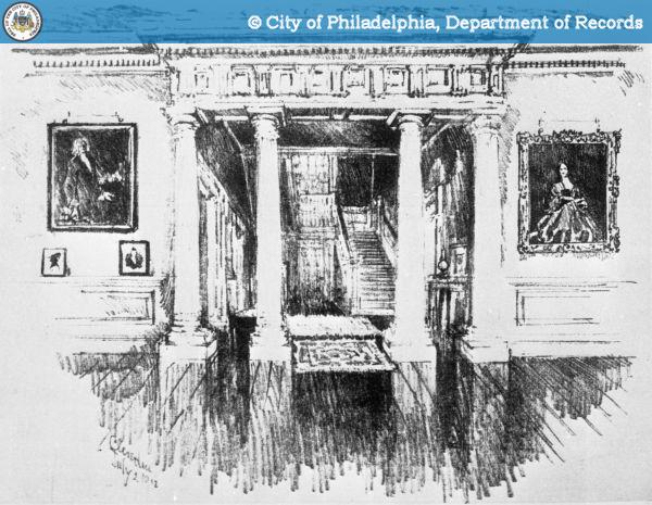

Purchase Photo View Nearby Photos
Artist’s sketch of the Main Hall.

“Cliveden was not afraid to face what the papers reveal,” curator Phillip Seitz said. “What we realized was that the grandeur of Cliveden was the very top layer of a very complex onion, an onion that needed to be peeled back.”

Since the release of the Chew family papers, Cliveden’s management has engaged the surrounding community in a number of meetings and dialogues.  This past fall, Cliveden sponsored a series of four well-attended lectures entitled “Cliveden Conversations” in the former carriage house.  Speakers included Phillip Seitz, who discussed the Chew family’s involvement with slavery; Dr. Erica Dunbar-Armstrong of the University of Delaware, who gave a broad overview of slavery in the Mid-Atlantic region from a woman studies perspective; Ari Merretazon of N’COBRA, who discussed his organization’s goal of reparations for the descendants of slaves; and Dr. David Young, Cliveden’s executive director, who framed the house in the context of 20th century race relations in Germantown.[iv]

Cliveden’s management hopes not only to bring about racial healing, but to more fully integrate their house museum into the predominately African-American Germantown neighborhood, making themselves “a catalyst for preserving and reusing historic buildings to sustain economic development for historic Northwest Philadelphia and beyond.”[v]


Purchase Photo View Nearby Photos
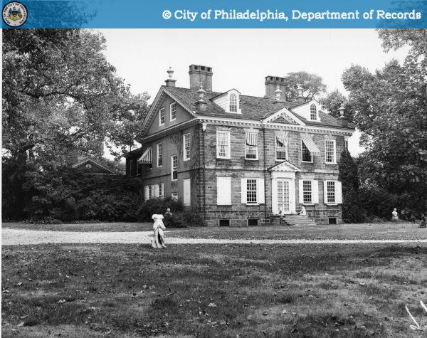
Photograph of Cliveden, 1957. The Chew family owned the
mansion until 1972.

“We are giving people what they want,” Seitz said. “They don’t want more exhibits. They want story tellers, news articles, and they need affirmation that things happened here…not just bad stories, but also stories of survival.”

John Reese agreed. “Let’s have the courage to confront this.”  For his part, Reese sees Cliveden in a positive light, now that a more complete story is being told.  Exploring the house’s history was also a catalyst for friendships with curator Phillip Seitz and board member John Chew Jr.

“I love the house,” Reese said, sitting on a picnic table in the shadow of the craggy stone mansion. “That banister in the main staircase is solid as a rock. You look at how flimsy houses are today, and I have a hard time ever seeing Cliveden getting blown down.”

Special thanks to Philip Seitz, John Reese, and John T. Chew Jr. for their time and insights.  The interviews were conducted on October 8, 2010 at Cliveden.


[i] “Legends of the Bar,” The Philadelphia Bar Association. http://www.philadelphiabar.org/page/AboutLegends?appNum=4 Accessed October 18, 2010.

[ii] Benjamin Chew Jr. to Benjamin Chew Sr., November 15, 1809. The Chew Family Papers, Historical Society of Pennsylvania, Philadelphia, Pennsylvania. http://www2.hsp.org/collections/manuscripts/c/Chew2050.xml#series2 Accessed October 16, 2010.

[iii] “N’COBRA Information” http://www.ncobra.com/ncobra_info.htm Accessed October 18, 2010.

[iv] ‘Cliveden Conversations,” Cliveden: A National Trust Historic Site in Philadelphia.” http://cliveden1767.wordpress.com/visiting-cliveden/calendar-of-events/ Accessed October 18, 2010.

[v] “Mission Statement,” Cliveden: A National Trust Historic Site in Philadelphia.” http://cliveden1767.wordpress.com/mission-statement/ Accessed October 18, 2010.

Categories
Historic Sites

Risen from the Ashes: St. Joseph’s Preparatory School and the Gesu Church, Part 2

As the Gesu parish flourished, so did St. Joseph’s Preparatory School. By 1927, the University moved from North Philadelphia to a new campus on City Line Avenue, giving the secondary school much more space. It was also in the 1920s that the school became known as “The Prep” and its students as “Preppers.” Because of its high academic standards, easy access to public transportation, and relatively low tuition, it attracted students from all over Philadelphia and its suburbs. Some hailed from as far away as Trenton, Phoenixville, and Cape May. Some of their fathers were doctors and lawyers; others were factory workers and shop owners. Most parents were upwardly-mobile and very involved in their children’s education. Above all, the school was a Philadelphia melting pot. As Preppers, students could form friendships outside of their respective economic classes and neighborhoods.


Old St. Joseph’s Preparatory School and University,
c.1910. Collection of St. Joseph’s Preparatory School.

The Marble Staircase, the old St. Joseph’s
Preparatory Building, c. 1925, Collection of
St. Joseph’s Preparatory School.

According to a school history, the Jesuits impressed upon their charges that they should be “polite, as that is the surest sign of a gentleman and therefore they should diligently observe all the little customs prescribed by their teachers.” The students were also told to be “friendly with their peers and avoid quarreling, fighting, and language of low-breeding.” iii


Classes began at 9am and continued until 2:30pm. Students then participated in extracurricular activities and sports, with football being the most popular. Coach Frank Caton of the Fairmount Rowing Club started the crew team in the late 1920s. A dramatic club put on Shakespeare plays, and those interested in debate participated in the Barbelin Society — talented Jesuits advised both groups.iv

Sandy MacMurtrie, class of 1945, commuted to The Prep from his family’s home at 912 S. 49th Street. His family, parishioners at St. Francis de Sales Church on Baltimore Avenue, sent three sons to the Prep. Sandy and a few of his West Philadelphia classmates would catch the Number 70 trolley to Girard Avenue, and then hop the Number 15 to 17th Street. Mass would be said at 8am every day, with prayers offered to the alumni in the service — including Sandy’s brother Francis who was tragically killed in the Pacific.

The situation in Europe cast a shadow over school life, but the students still pulled old fashioned hijinks. In September 1941, The Prep scored a major football victory over South Catholic High School. The following morning, students held a celebratory pep rally in the auditorium. No one knows who walked out the door first, but scores of Preppers (including MacMurtrie) paraded down Broad Street, cheering and singing at the top of their lungs. The headmaster met the students at Rayburn Plaza and ordered them to turn around. To no avail. By the time the students reached South Catholic at 8th and Christian, the Prep’s headmaster had sent several squad cars there to meet them. The administration punished the offending students accordingly: for the next 2 days after school, they had to walk in circles around the schoolyard for 3 hours.v

* * * *

Within days of the fire of 1966, the Prep was back in business. Classes met in the one surviving building on Thompson Street. In spite of crowded and primitive conditions, enrollment did not decline. Most importantly, the administration decided the school would remain in North Philadelphia.

For teacher Gus Kueny Jr. ‘53, the decision to stay was a reaffirmation of the school’s social mission. “So many businesses and schools are closing up and leaving the city,” Kueny said at the time. “What could we accomplish by moving out? Kids come here from every neighborhood, from every suburb. For kids like this, just coming into this neighborhood shows them something they wouldn’t see out in the suburbs. It’s part of their education.” vi

The new school building would be built just south of the Church of the Gesu, on land acquired from the Philadelphia Redevelopment Authority. Ground was broken on May 29, 1967, and Cardinal John Krol consecrated the modern, $4.5 million structure a year and a half later.vii


Exterior of the old St. Joseph’s Preparatory Building
and Church of the Gesu, c. 1960, Collection of
St. Joseph’s Preparatory School.

Interior of Church of the Gesu, photograph by
Steven B. Ujifusa.

In the 1990s, due to falling parish membership, the Archdiocese of Philadelphia deactivated the Church of the Gesu as a parish. But St. Joseph’s Preparatory stepped in to save Father Villiger’s dream church. This remarkable structure now serves as the school’s chapel, hosting student masses several times a year. Its attached independent school, the Gesu School, is a model for inner city elementary education.

Today, The Prep has about 800 students, and continues to draw in students from all over the Philadelphia area. Despite its urban location, the Prep has found that more and more of its students are from the suburbs. Naturally, this has led to some tensions with the surrounding neighborhood, especially as the student body became more affluent. At the same time, the Prep opportunities for community service not possible in a suburban location, such as tutoring low-income elementary students at the Gesu School.

“We’ve been struggling to keep a base in the city,” said current headmaster Father George Bur S.J., ’59. “When I was there as a student, between 60 and 70 percent the students were from the city, now it’s only about 20 percent, and we are working to reach out to the Latino and African-American communities.” viii

A recent alumnus, Richard Pagano ’98, recently mused on the meaning of the school’s motto “Men for Others”: “Community service,” he said, “and the idea of commitment to aiding and providing for not only those less fortunate, but the community as a whole, is such a big part of that school. The school imbues in you a desire to succeed, to achieve, to make a name for yourself, and not to be complacent…the school’s location, and Jesuit ideals, cannot be discounted for doing that.”

Note: Special thanks to Bill Avington, Bill Conners, Father George Bur S.J., James Hill Jr., Gus Keuny, Sandy MacMurtrie, and Richard Pagano for their invaluable assistance.

References:

[iii] Rev. James J. Gormley, S.J., Saint Joseph’s Preparatory School, A History 125 Years, 1851-1979, Philadelphia, Pennsylvania: Saint Joseph’s Preparatory School, 1976, p.12. Collection of St. Joseph’s Preparatory School, Philadelphia, Pennsylvania.

[iv] Rev. James J. Gormley, S.J., Saint Joseph’s Preparatory School, A History 125 Years, 1851-1979, Philadelphia, Pennsylvania: Saint Joseph’s Preparatory School, 1976, pp.46, 65, 105.

[v] Interview with Sandy MacMurtrie, August 27, 2010.

[vi] James Smart, “In Our Town: A Sentimental Alumnus Busy Rebuilding the Prep,” The Evening Bulletin, November 8, 1968. Collection of St. Joseph’s Preparatory School, Philadelphia, Pennsylvania.

[vii] Rev. James J. Gormley, S.J., Saint Joseph’s Preparatory School, A History 125 Years, 1851-1979, Philadelphia, Pennsylvania: Saint Joseph’s Preparatory School, 1976, pp.155-156. Collection of St. Joseph’s Preparatory School, Philadelphia, Pennsylvania.

[viii] Interview with Father George Bur, S.J, August 27, 2010.

Categories
Historic Sites

Risen from the Ashes: St. Joseph’s Preparatory School and the Gesu Church, Part 1


Old St. Joseph’s Preparatory School on fire,
January 30, 1966. Collection of St. Joseph’s
Preparatory School.
On the early morning of January 30, 1966, a watchman spotted a fire smoldering in the basement of St. Joseph’s Preparatory School. He alerted Brother Stanley Leikus, S.J., who ran onto Stiles Street at 5:30am and pulled the firebox. But it was too late. The blaze ripped through the century-old Second Empire style main structure, consuming classrooms, libraries, and the white marble staircase at the school entrance.
Within an hour, eight fire companies had arrived at St. Joseph’s Preparatory, but high winds whipped the flames into a ferocious firestorm. It was a bone-chilling ten degrees, and giant sheets of ice from the fire hoses encrusted the blazing building’s façade.

At the neighboring Gesu Church, Jesuit brothers gathered up relics and vestments and moved them to safety. With smoking billowing around him, Headmaster Joseph Ayd S.J. shut the fire doors separating the burning school and the Gesu Church and then fled for his life.


After the fire. Collection of St. Joseph’s
Preparatory School, January 30, 1966.

After the fire. Collection of St. Joseph’s
Preparatory School, January 30, 1966.

At 8:00am, the Stiles Street building of St. Joseph’s Preparatory collapsed with a great roar, and a shower of sparks rained down upon the Gesu Church. If the Gesu’s wooden structure caught fire, the flames would almost certainly spread to surrounding houses.

Finally, at 9:13 am, the fireman had brought the blaze under control. The Gesu Church and its parish school were safe. But St. Joseph’s Preparatory School was a total loss, a blackened, gutted shell of its former self. Its 800 students were homeless, as well as its 40 Jesuit priests.i

There was no question that “The Prep” would rebuild. It was one of the crown jewels of Philadelphia’s Catholic school system, taking in bright boys and giving them opportunities they otherwise would have been denied. As a result, it had a loyal alumni base. But at the time of the fire, North Philadelphia was in severe economic decline, and many wondered if the school would move elsewhere and cater to a more affluent suburban clientele.

* * * *

St. Joseph’s Preparatory is an outgrowth of the oldest Roman Catholic parish in Philadelphia: St. Joseph’s Church, founded in 1733 by the Society of Jesus and located at 3rd and Walnut. Thanks to William Penn’s “Charter of Privileges,” St. Joseph’s Church was the only place in the British Empire where people could publically celebrate a Roman Catholic Mass. Following American independence, the parish, as well its college preparatory school (founded in 1851), grew by leaps and bounds, thank in large part to an influx of Irish and German immigrants. But by the mid-nineteenth century, the Jesuits were running out of space and needed to move.

In the 1860s, the Jesuits brought in Swiss-born Father J. Burchard Villiger to raise funds to build a new complex for the preparatory school and university. Villiger, educated at Georgetown University, had a genius for networking with the city’s upwardly mobile Roman Catholic elite, most notably the Drexels and Bouviers. In 1866, the Jesuits bought the entire 1700 block of Stiles Street in then-rural North Philadelphia as the site for a Catholic preparatory school and university. Appropriately, it was only a few blocks away from the Bouvier mansion on North Broad Street. Villiger quickly raised the money to build a large Second Empire-style school and university building, which boasted eighteen foot ceilings, a white marble staircase, and mansard roofs.

He then turned his attention to building a parish church, which would also be utilized by the school and university. His model was the home church of the Society of Jesus in Rome: hence, it would be named the Church of the Gesu. In 1878, Archbishop Frederic James Wood gave Villiger permission to start building to a set of plans by architect Edwin Forrest Durang.

Villiger planned on a grand scale: the church would be 115 feet wide and 250 feet deep. Its highest vault would soar 100 feet above the nave’s floor. Villiger purchased five bells for the towers, as well as a set of ecclesiastical paintings by Mexican artist Miguel Cabrera. He also had a passion for collecting relics, to be displayed in reliquaries set in the church’s side chapels.

But even the persuasive Villiger had trouble the raising funds to achieve his vision. Construction of the church took a decade and proceeded fitfully. He hoped to use gleaming marble to adorn the interior of the church. As a fundraising ploy, Villiger had the interiors completed in raw white plaster. According to a history of the church, the savvy Jesuit reasoned that “people would grow tired of it and buy the marbles of which he dreamed.” Ultimately, the white interiors were elaborately painted in a faux-marble finish by Brother Schroen, S.J.


Easter Sunday Mass at the Church of the
Gesu, 1913. Collection of St. Joseph’s
Preparatory School.

If Villiger couldn’t get his marble trim, he did secure a hefty $72,000 gift (over $1.5 million in today’s money) from the estate of Francis A. Drexel to complete the church, which was dedicated with great pomp in 1882. By the time Villiger died in 1902, critics had hailed the Gesu as one of the most beautiful sacred spaces in the city and a fittingly grand chapel for St. Joseph’s Preparatory School and University.ii

Note: Special thanks to Bill Avington, Bill Conners, Father George Bur S.J., James Hill Jr., Gus Keuny, Sandy MacMurtrie, and Richard Pagano for their invaluable assistance.

References:

[i] “8-Alarm Fire Wrecks St. Joseph’s Prep School,” The Evening Bulletin, January 31, 1966.

[ii] Golden Jubilee, 1888-1938, Church of the Gesu, Privately printed: Philadelphia, Pennsylvania, 1938, pp. 14, 15, 30, 32, 111. Collection of St. Joseph’s Preparatory School, Philadelphia, Pennsylvania.

Categories
Historic Sites

As Long as the Creeks and Rivers Run: Traces of the Lenni Lenape – Part II: Along the Schuylkill

By Shawn Evans, Atkin Olshin Schade Architects

Part I of this tour traced Lenni Lenape places along the Delaware River. The tour continues up the Schuylkill River.

One of the largest Lenape settlements was located on the eastern shore of the Schuylkill, just north of the Delaware. Numerous spellings of this area have been recorded, among them Pachsegink and Pachsegonk, meaning “in the valley.” i Now an industrial area along the riverbanks, Passyunk survives in name as one of the diagonal roads that cut through the city grid. Frequently referred to an “Indian trail,” a portion of the street east of Broad (seen here in 1946) has recently been rebranded with large cast Indian head medallions set into the sidewalk. Historical photographs of the League Island Park (now FDR Park) prior to its re-grading by the Olmsted Brothers in 1914 provide views of how this part of town may have appeared during Lenape inhabitation.

Across the river from Passyunk was Kingsessing, the Lenape name for the land between the Schuylkill River and Cobbs Creek. Kingessing is derived from Chingsessing, meaning “a place where there is a meadow.” ii A Lenape village known as Arronemink, alternatively spelled “Aroenameck,” “Arronemink,” and “Arromink,” was located at the mouth of Mill Creek, which flowed into the Schuylkill just south of the Woodlands Cemetery. A post on the Woodland Indians Forum identified a possible meaning of Arronemink as “place where the fish cease,” a possible reference to natural falls in this area.iii Coaquannock, “grove of tall pines” was a Lenape settlement north of Center City on the east bank of the Schuylkill.iv


The next village up the Schuylkill was Nittabakonk, “place of the warrior.” v Located on the east bank of the river, just south of the Wissahickon Creek, this area is now known as East Falls. There are no falls in the river in the vicinity any longer, as the 1822 construction of the Fairmount Dam substantially raised the water level in this area. This part of the river was known to the Lenape as Ganshewahanna, meaning “noisy water.” vi This 1910 photo of the City Line Bridge shows the water after they were quieted.

The Wissahickon creek retains its Lenape name. The Anglicized spelling is believed to be derived from Wisameckhan, meaning “catfish stream.” vii The Wissahickon Valley Park is among the best places in Philadelphia to see a largely unaltered natural landscape. A variety of bridges span the creek, including smaller bridges for pedestrians accessible within the park, as well as large engineering marvels like the Henry Avenue Bridge that connects opposite hillsides and communities not visible within the park. A statue of a Lenape warrior, carved in 1902 by John Massey Rhind, kneels on a cliff overlooking the Creek near Rex Avenue.viii

Perhaps the place name most associated today with the Lenape is Manayunk. This Lenape word simply means river, literally “place where we go to drink,” and does not specifically refer to the Schuylkill River or any particular place on its banks.ix As with most Lenape place names, several spellings have been utilized including Mëneyung, Meneiunk, and Manaiung. The last of these spellings is used in the correspondence between William Penn and the Lenape. Manayunk was selected as the name for this growing neighborhood in 1824.x Manayunk remains a place to drink, although no longer from the river itself.

The 1682 Treaty of Friendship was forged in Shackamaxon (see Part I) with the assumption that the rivers and creeks of Philadelphia would always run – this would of course not be the case.xi In 1737, the Lenape were tricked by William Penn’s sons into relocating to nearby river valleys and were eventually forced by the federal government to relocate to Oklahoma.xii Two federally recognized tribes of Lenape remain in Oklahoma today, the Delaware Nation (aka Western Delaware) and the Delaware Tribe of Indians (aka Eastern Delaware) with populations of 1,422 and 10,529 respectively. The Lenape Nation of Pennsylvania, a community of Native Americans in the Lehigh Valley is not federally recognized but is actively reviving their language and culture.xiii The exhibit, “Fulfilling the Prophecy: the Past and Present of the Lenape in Pennsylvania,” on display through 2011 at the Penn Museum presents the story of the Lenape who managed to stay behind during the forced migrations.xiv The Lenape Nation of Pennsylvania is currently seeking state recognition and a new Treaty of Friendship is collecting signatures.


References:

[i] Cotter, John L., Daniel G. Roberts, and Michael Parrington. The Buried Past: An Archaeological History of Philadelphia. Philadelphia: University of Pennsylvania Press, 1992, p.28.

[ii] Mary Maples Dunn and Richard S. Dunn. “The Founding, 1681-1701.” In Philadelphia: A 300-Year History. ed. Russell F. Weigley. New York: W.W. Norton Co., 1982, p.4.

[iii] “Arronimink.” Woodland Indians Forum. http://woodlandindians.org/forums/viewtopic.php?pid=18959, accessed 6/23/2010.

[iv] Cotter, p.27.

[v] Cotter, p.27.

[vi] “A History of East Falls.” Preserve Philadelphia Website. http://www.preservephiladelphia.org/neighborhood/detail.php?nh=68, accessed 6/23/2010.

[vii] Cotter, p.29.

[viii] Friends of Wissahickon website, http://www.fow.org/sstatue.php, accessed 6/23/2010.

[ix] Cotter, p.29.

[x] “Plan Philly: Main Street Manyunk,” http://planphilly.com/main-street-manayunk, accessed 6/23/2010.

[xi] See Philly H2O: The History of Philadelphia’s Watersheds. http://www.phillyh2o.org/, accessed 6/23/2010.

[xii] Delaware Tribe website, http://www.delawaretribeofindians.nsn.us/walking_purchase.html, accessed 6/23/2010.

[xiii] Lenape Nation of Pennsylvania website, http://www.lenapenation.org/main.html, accessed 6/23/2010.

[xiv] Penn Museum website, http://www.penn.museum/current-changing-exhibits/158-fulfilling-a-prophecy-the-past-and-present-of-the-lenape-in-pennsylvania.html, accessed 6/23/2010.