Categories
New Features

PhillyHistory Now on Twitter!

We’re excited to announce that the PhillyHistory team is now on Twitter! A microblogging site, Twitter lets users post messages that are 140 characters or less. Many libraries, archives, and museums have Twitter accounts and use them as a way to share information about their institutions and respond to questions from the public.

Follow the PhillyHistory Team on Twitter at @phillyhistory

We’re hoping to use our Twitter account as a way to give you a glimpse of the behind the scenes work of the PhillyHistory team. We’ll be posting news about PhillyHistory projects as well as letting you know about interesting history related events, news, and exhibitions happening in the area. Around lunchtime each day, we will also be posting our PhillyHistory Photo of the Day” – an image that caught our eyes or that we thought deserved a little bit more attention.

If you are a Twitter user, you can follow or message us at @phillyhistory. Not on Twitter? You can still read our posts at http://twitter.com/#!/phillyhistory

Categories
Behind the Scenes

Getting Meta with Metadata

Metadata. This rather ambiguous term is the skeleton underneath every image on PhillyHistory.org. Metadata is how we know when and where a photograph was taken. It is how we know who took the photograph and, to some extent, why they took it. Without metadata, searching PhillyHistory.org for photographs of Independence Hall or your grandmother’s house would be nearly impossible. But what is metadata?!

Metadata is essentially “data about data,” meaning information about any type of “data” – whether it’s a letter, a photograph, a painting, or even a piece of furniture. Metadata can range from the time and date something was created to who created it and even the reason behind its creation. At its core, metadata allows us to describe an object and, in the case of databases like PhillyHistory.org, use that description to locate one item out of thousands. When you enter a book’s title and author into a library catalog, you’re using metadata to find the specific book you want to read. Similarly, when you search PhillyHistory.org for a photograph taken at a specific location, that location and any other information about the photograph is metadata.

Each image on PhillyHistory.org is connected to an administrative page where members of the PhillyHistory team can enter metadata information.

Before we upload a new photograph to PhillyHistory.org, we first create a database record, known as an “asset,” that details as much information as possible about the image. For the majority of the photographs in our collections, this includes a title, description, photographer name, location, and date, as well as the photograph’s record group and negative number. By and large, this information is taken from the original envelope containing the negative or from a log book kept by the photographers as shown here.

A photographer's logbook provides metadata for many of the historic images.

When entering metadata into a new record, we follow certain standards, commonly known within the archival community as “best practices.” Perhaps the cardinal rule of metadata is that all information must be entered as it appears in the original historical record. In our case, this means entering each title as the photographer recorded it in the log book or on the original envelope, even if the title is as general as “Houses, Stores, Etc.” In these instances, PhillyHistory.org users or one of the members of the PhillyHistory team often recognize a building or a house and suggest a better title for the photograph, but, according to the rules of metadata, we can’t change the title. Instead, additional details from a user or one of our archivists are entered in the “Notes” field. In a PhillyHistory.org record, the “Notes” field is our chance to add anything the photographer forgot or to correct something that is wrong or misleading. One common correction involves location, as the location the photographer recorded is sometimes not the one pictured in the photograph but rather the location from which the photograph was taken. In these cases, we title the photograph just as the photographer did, “Northeast Corner of 12th and Market Streets” for example, but leave a note about the difference between the photographer’s location and the location pictured in the photograph.

One other fun fact about metadata – if a photographer misspelled a street name, best practices tells us to enter the street name as the photographer recorded it, followed by the correct spelling in brackets. In the archival world, brackets indicate a change or addition to the original historical record and are peppered throughout the records on PhillyHistory.org. In this way, metadata is also about translating records that someone wrote fifty or a hundred years ago, an endeavor almost as challenging as understanding metadata!

Managing metadata in an archive comes with all sorts of additional and complex issues. For more information beyond this brief introduction, visit the following links.

“Metadata Resources” – Compiled by the Minnesota State Archives.

“Metadata Standards/ About” – Compiled by the Princeton University Library.

“Understanding Metadata” – Published by the National Information Standards Organization Press in 2004.

“Getting Meta with Metadata” is the second article in “Behind the Scenes at PhillyHistory.org,” a new series of blog entries that will provide insights into the activities that go into creating PhillyHistory.org.

Categories
Snapshots of History

Food Will Win the War


Purchase Photo View Nearby Photos
Supply trucks gathered at City Hall.

World War I is often referred to as the first “modern war.” Weapons such as airplanes, tanks, machine guns, and chemicals were used for the first time with deadly consequences. However, one of the oldest weapons in human history was also employed during the War – food. Starving a city or fortress to surrender is a tactic that dates back to ancient times. History has shown that in matters of war the victor is not always the one with the largest army or most advanced weapons. Often, it is the one who can continue to feed its army and citizens. World War I was no different. As Europe sent its most able-bodied young men into the trenches, food production began to decrease. The United States, being a neutral country at this point and possessing a surplus of food, became critical in supplying food to its (unofficial at the time) allies in Europe.

By the time America entered the war in April 1917, however, European demand had depleted food reserves and driven up prices. Since farmers could not increase production until the following year’s harvest, it became clear that America would have to conserve food if it was to continue to feed itself, its growing and mobilizing army, and its allies. Federal legislation was introduced to control food supplies, but a frustrated President Woodrow Wilson felt that something needed to be done faster. Wilson urged the passing of the Lever Food and Fuel Control Act in 1917 as an emergency wartime measure. With its passing, the Lever Act created the United States Food Administration to control the growing supply problem. President Wilson appointed as head of the administration a man who would later become president himself – Herbert Hoover. Hoover had previously been in London organizing, sometimes surreptitiously, relief efforts for the people of Europe, especially in Belgium.


Purchase Photo View Nearby Photos
City Hall illuminated at night with Hoover’s famous slogan.


Hoover believed that “food will win the war” but did not want to embark upon a rigid and mandatory rationing program. He believed that in “the spirit of self-denial and self-sacrifice” Americans would voluntarily modify their eating habits. A national campaign, mostly aimed at women, was introduced to encourage conservation of food and the elimination of waste. Special recipes and cookbooks were disseminated. Victory Bread, bread made with a flour substitute called (appropriately) Victory Flour, became a staple in many homes. Nation-wide weekly events such as “Meatless Mondays” and “Wheatless Wednesdays” were promoted. Children were told to east less sweets in order to “save sugar for a soldier.” Supply-truck motorcades were organized to bring food directly from rural areas into major cities and ports, with Philadelphia being a major hub of this kind of activity. In public spaces throughout the country, cities prominently displayed signs and posters bearing Hoover’s famous statement “Food Will Win the War.” Americans began to informally refer to their modified eating habits as “Hooverizing.”


During the first year of the U.S. Food Administration’s existence, Americans reduced their food consumption by 15 percent. That number may not sound like much, but it doubtless fed many a starving ally or American doughboys across the Atlantic. After the war, Hoover continued the humanitarian efforts of the U.S. Food Administration, which had been reorganized and renamed the American Relief Organization. Hoover expanded relief to include not just America’s allies but also it’s recently defeated former enemies, declaring “Twenty million people are starving. Whatever their politics, they shall be fed!”

“Hooverizing” recipes are widely available. For the recipes and to see the finished products, please visit http://foodwillwinthewar.blogspot.com/.

Sources:

“Wilson Orders Hoover to Start.” The New York Times, June 16, 1917. Accessed June 16, 2011. http://query.nytimes.com/mem/archivefree/pdf?res=FA0711FD385E11738DDDAE0994DE405B878DF1D3.

Goudiss, Alberta Moorhouse and Charles Houston Goudiss. Foreward to Foods That Will Win the War: And How To Cook Them. New York: The Forecast Publishing Company, 1918. Accessed June 16, 2011. http://books.google.com/books?id=k9sqAAAAYAAJ

Hammond, R.J. “Review of The History of the United States Food Administration, 1917-1919 by William C. Mullendore.” The English Historical Review, vol. 58, no. 230 (April 1943). Accessed June 16, 2011.

“Food Will Win the War” is part of “Snapshots of History,” a new series of blog entries that will provide background info on select images from the PhillyHistory.org database.

Categories
Behind the Scenes

Oh Where Can This Be?: Photos Without a Location

When we enter new photographs into the PhillyHistory.org database, we include as much information as possible about an image from the date and photographer’s name to the location. Without a doubt, location is one of the most important parts of our photo collections as many of the historic images depict street scenes and the exterior of buildings. Whenever possible, we try to geocode (assign latitude and longitude coordinates) to an image. We can geocode a photo by identifying an address, street intersection, or place name (such as City Hall) or by selecting a point on a map. The software behind PhillyHistory.org will take this information and calculate the latitude and longitude coordinates associated with that spot. Once a photo has been geocoded, users can search for and find the image based on its geographic criteria. The geographic location of a photo is crucial as PhillyHistory.org users search for images by address or neighborhood more than keyword or any other search criteria. If a photo has an identified location, users also can download it to Google Earth or compare the historical images with the present-day Google Street View.

However, what we know about a photo depends upon what information the photographer left behind. Sometimes, we unfortunately have little or no knowledge of where a photo was taken. Photographs of bridges, railroads, and creeks are among the most challenging to locate since the photographer’s terminology is frequently too broad or too narrow for our purposes. In some instances, photographers used surveying markers to describe their location, but unfortunately “North from Station 109+70” can’t tell us exactly where a photo is located along the Frankford Creek. Alternately, some locations were recorded in very basic terms. In these cases, tracking down an address often requires some ingenuity and super sleuthing, along with a little help from our friends.

So how do we do it? Here’s an example using a PhillyHistory.org image taken on March 27, 1898.


Purchase Photo View Nearby Photos

The title, “Broad Street Bridge,” places the photo at any number of locations along Broad Street. When the title and the description provided by the photographer prove vague or indefinite, we turn to the photo for more details. Fortunately, the photo itself provides a few clues; we can see that this was a railroad bridge and there is a sign on the right-hand side building that reads “Gas And…” Following these leads, I turned to the Greater Philadelphia GeoHistory Network (www.philageohistory.org), a pilot project of the Philadelphia Area Consortium of Special Collections Libraries and now led by the Athenaeum of Philadelphia.

Among other resources, the GeoHistory Network provides digitized copies of historical maps and atlases from the nineteenth and twentieth centuries, along with an awesome interactive maps viewer that allows users to zoom in on a location and compare the historic map with the current street grid. To find a location for this photo, I used the 1910 Philadelphia Atlas by G.W. Bromley. Following North Broad Street from City Hall, I found the old Philadelphia and Reading Railroad freight yard at North Broad and Callowhill Streets, which seemed like a good candidate for this photo’s location. To confirm my suspicions, I scanned the map area, which lists business names on the building outlines, and found the Horn and Brannen Gas and Electric Fixtures Factory at the next intersection – North Broad and Noble Streets. This matched the “Gas And…” sign visible on the right-hand side of the photo and, to make my final determination, I zoomed in on a high resolution copy of the image. Not only was the full factory name visible, but the building on the left-hand side turned out to be the Baldwin Locomotive Works, which was also visible on the map. Satisfied with my findings, I geocoded this photo to North Broad and Callowhill Streets and set the Street View to look north toward the intersection of Broad and Noble Streets.

Often, the maps from the GeoHistory Network are an invaluable resource in our efforts to locate photos; additionally, we also rely on the knowledge of our users who can submit comments and error reports for any photo on PhillyHistory.org. As the story of this one photo shows, sometimes all it takes is a keen eye, a bit of research, and a little luck to solve the mystery of photos without a location.

“Oh Where Can This Be?” is the first article in “Behind the Scenes at PhillyHistory.org,” a new series of blog entries that will provide insights into the activities that go into creating PhillyHistory.org.

Categories
Entertainment Neighborhoods

Neighborhood Movie Theaters

Shawn Evans, AIA, Atkin Olshin Schade Architects

Center City Philadelphia was home to the region’s most well known movie theatres.  Clustered in districts on Market, Chestnut, South, and North 8th Streets, these entertainment venues lined up along the sidewalks with blinking lights and glistening facades to draw in thousands of visitors to downtown.  An earlier blog post, “Historic Movie Theatres of Center City Philadelphia,” chronicled some of these places that are documented in the photograph collections of the Philadelphia City Archives.   Whereas downtown movies were for most people a special treat, the neighborhood theatres were a more integral part of weekly life. [i]

WEST PHILADELPHIA


Purchase PhotoView Nearby Photos

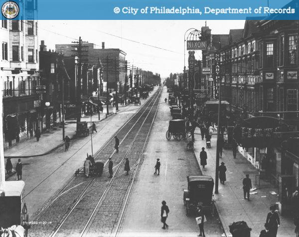
52nd Street in 1914, looking south from Market. Nixon Theatre
seen on right.


Purchase PhotoView Nearby Photos

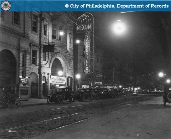
Nixon Theatre, 28 South 52nd Street, seen here in 1914.

Many of the neighborhood theatres were located in commercial corridors.  West Philadelphia’s main street for well over a century has been 52nd Street.  For much of its history, the Nixon Theatre lit up its night.  Originally a vaudeville theater operating under a tent, the grand Nixon was built in 1910 near the head of the vibrant commercial strip.   The 1,870 seat theater was designed by architect John D. Allen, who had recently designed the much more elaborate Orpheum Theatre on West Chelten Ave.  Converted to film presentation in 1929, the Nixon operated until 1984.[ii] The brick and stone classical façade featured a two-story arched entrance, topped with a gentle bow window, and a prominent baroque split pediment.[iii] The site is now occupied by a nondescript building housing Payless ShoeSource and Rainbow Kids.


Purchase PhotoView Nearby Photos

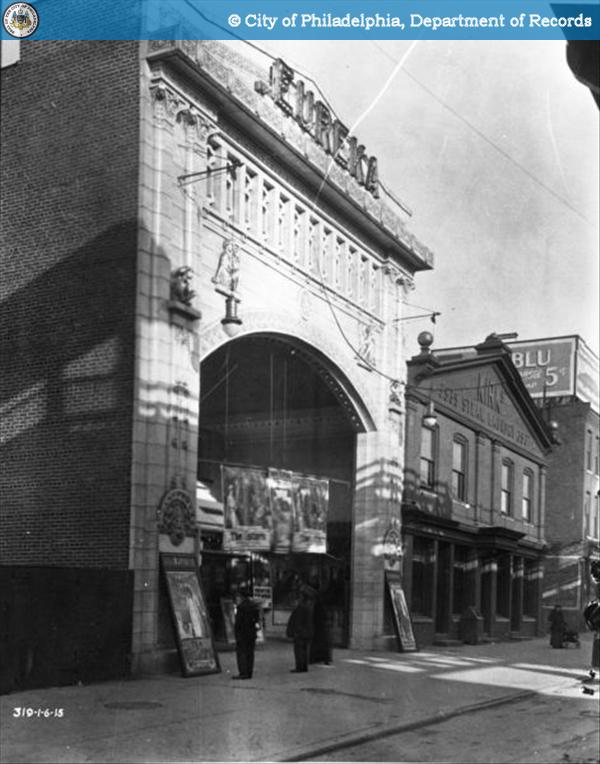
Eureka Theatre, 3941 Market Street, seen here in 1915.

Another eye-catching classically designed theatre in West Philadelphia was the Eureka Theatre.  While the building had a much smaller capacity of 450 seats, the large terra cotta façade was designed to be seen from a fast moving train on the elevated Market Street line just feet away.  Designed by Stearns and Castor, now best known for their Colonial Revival homes, the Eureka opened in 1913 and operated through the 1950s when it was converted into a furniture store.[iv] It was demolished in the 1970s to make way for the high-rise which is now the University Square retirement home.


Purchase PhotoView Nearby Photos

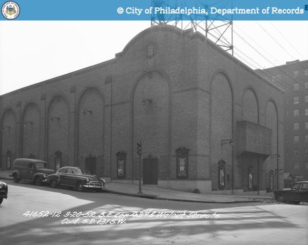
Commodore Theatre, SE corner of 43rd and Walnut, seen here
in 1952.

Many of the neighborhood theater buildings have survived but today serve other purposes.  The 1,105 seat Commodore Theatre in Walnut Hill opened in 1928.[v] Designed by the Ballinger Co., the Moorish styled building was converted in to the Masjid Al-Jamia mosque in 1973.  While the interior’s Moorish ornamentation was thematically appropriate for a mosque, much of it seems to have been removed.[vi] The theater was designed for film, but transitioned to legitimate theatre (with a thrust stage) in the 1960s for a few years before becoming the Miracle Revival Tabernacle church, prior to its use as a mosque.  The large rooftop sign structure, now empty, was installed in the 1930s.

SOUTH PHILADELPHIA

Neighborhood theaters provided an air-conditioned respite from the grind of modern life.  This is perhaps best represented by the fictional 1930s South Philadelphia Paloma Theater in the 1995 film, Two Bits.  Twelve-year-old Gennaro spends the nearly whole film searching for two bits (a quarter) to see a film in his Mifflin Square neighborhood’s brand-new theatre.


Purchase PhotoView Nearby Photos

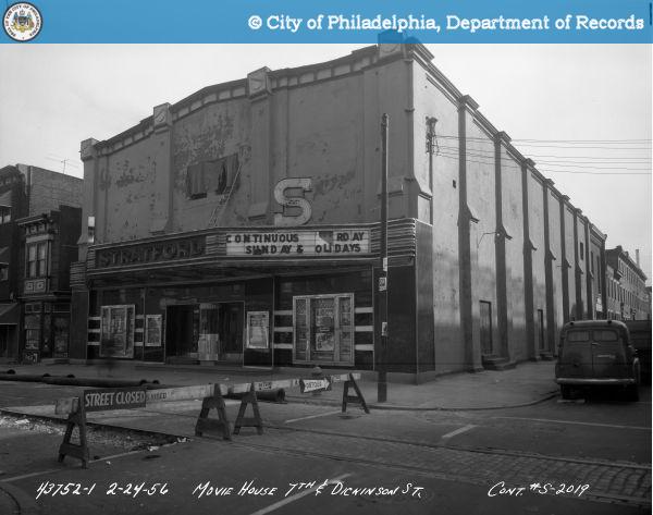
Stratford Theatre, South 7th Street and Dickinson, seen here
in 1956.

Prior to the Paloma, Gennaro might have walked fifteen minutes north to Dickinson Street to see a film at the 600 seat Stratford Theatre.  Opened as Herman’s in 1913, the theater became the Stratford in 1920 and showed movies into the 1960s when the building was acquired by the City and demolished for the parking lot that now occupies the site.[vii]


Purchase PhotoView Nearby Photos

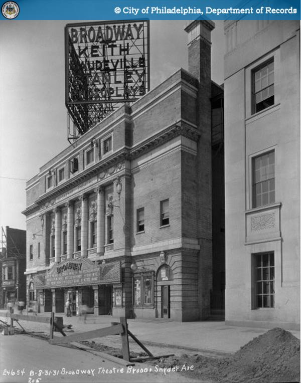
Broadway Theatre, South Broad and Snyder, seen here in 1931.

One of South Philadelphia’s largest and most popular theatres was the 2,183 seat Broadway Theatre.  The building was built in 1913 as a vaudeville theatre to the designs of Albert Westover, a theatre architect whose office was in Keith’s Theatre Building at 11th and Chestnut.  The theater was renovated in 1918 by Hoffman-Henon, the architects of the Boyd Theatre.  The refined white brick and terra cotta Broadway was demolished in the 1970s for a drive-through restaurant.  The site is now a parking lot for a Walgreen’s. [viii]

NORTH PHILADELPHIA


Purchase PhotoView Nearby Photos

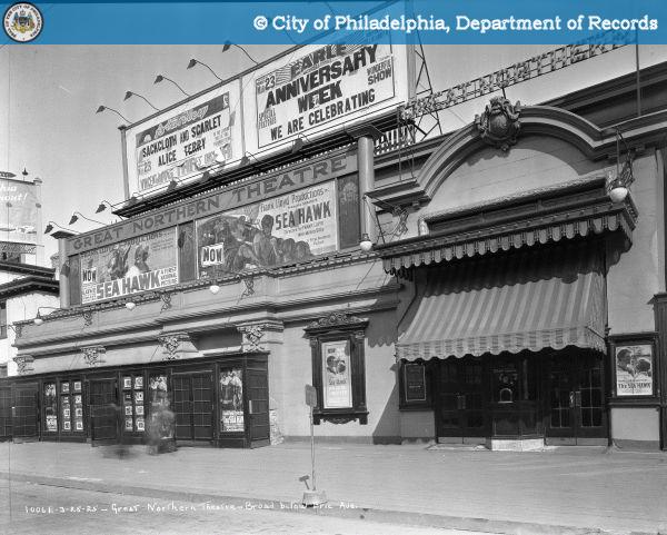
Great Northern Theatre, North Broad, Erie, and Germantown
Ave, seen here in 1925.

The 1,058 seat Great Northern Theatre was built on a triangular lot where Germantown Avenue crosses North Broad Street.  This large theater had entrances on both streets with a lobby at the point facing northwest.  A nickelodeon had been located here which was expanded in 1912.  This photograph, looking northeast to the Broad Street elevation, shows the pronounced advertising of the silent film, the Sea Hawk.  The theatre survived into the 1950s and was converted into a drug store in 1953. [ix] While the lobby portion was long ago demolished, the auditorium section of the building seems to have survived.


Purchase PhotoView Nearby Photos

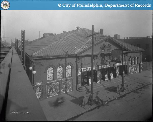
Jumbo Theatre, Front and Girard, seen here in 1916.

Also surviving as a shadow of its former self is the Jumbo Theatre.  This 1,300 seat theatre was constructed in 1909 to the designs of Carl Berger and renovated in 1912 by Hoffman-Henon Co. [x] Seen here in 1916, the theater is covered with signs about its “5 cent reels.” Said to be one of the largest theaters in the city when it opened, it showed films into the 1960s. As evidenced by the huge elephant sign suspended over the front doors, the theater was named after the famous elephant that P.T. Barnum bought from the London Zoo in 1882. The elephant was given the name Jumbo by the zookeepers and through Barnum’s publicity machine, Jumbo became synonymous with “huge.” [xi] (Remember that the next time you order a jumbo popcorn at the movies!) Recently operated as “Global Thrift,” the façade had been insensitively covered.  The building is currently being converted into a dollar store and the paneling has been removed, exposing the original ornamental brickwork.  The proscenium arch inside had survived until this spring.


Purchase PhotoView Nearby Photos

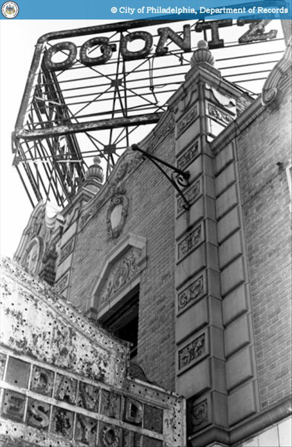
Ogontz Theatre, 6033 Ogontz Avenue, seen here in 1985.

The Ogontz Theatre was one of Philadelphia’s most beautiful neighborhood theatres.  Located in the West Oak Lane neighborhood, the Ogontz was designed in the Spanish renaissance style by Magaziner, Eberhard, & Harris.  This 1,777 seat theater opened in 1927, closed in the 1950s and was subjected to decades of neglect and vandalism prior to its 1988 demolition.[xii]


Purchase PhotoView Nearby Photos

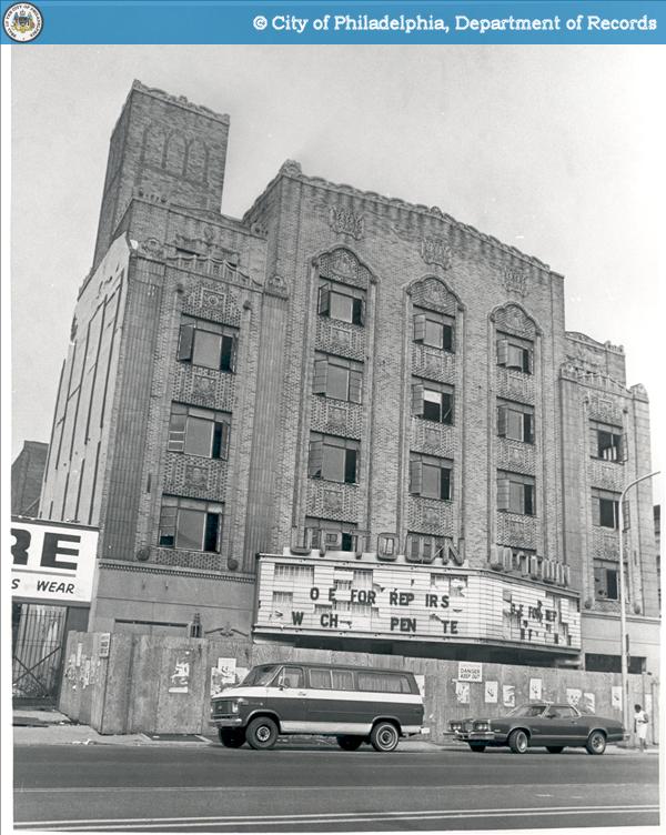
The Uptown Theatre, 2240 North Broad, Seen here in the 1970s.

The 2,146 seat Uptown was also designed by Magaziner, Eberhard, and Harris, and is considered one of their finest buildings.  As described in the 1929 opening day program, the building is “an Exquisite expression of 20th Century art. Grace of line, delicacy of coloring, beauty of craftsmanship, and mystery of scintillating and reflecting surfaces.”  Like many theatres of this period (the Boyd included) it was laid out for film more than vaudeville, and featured a narrow stage.  Despite this, the theatre became a major center of Philadelphia’s African-American culture in the 1950s.  It closed in 1978, briefly reopened in 1982, and is now the focus of an ambitious preservation effort by the Uptown Entertainment Development Corporation.[xiii]


Purchase PhotoView Nearby Photos

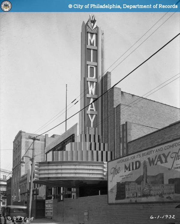
Midway Theatre, Kensington & Allegheny, seen here in 1932.

The Midway Theatre opened in 1932 in the Kensington neighborhood.[xiv] It  “was the last truly grand building of the motion-picture palace era in Philadelphia.”[xv] An art-deco show-stopper, the building could be seen down the avenue for blocks. The 2,727 seat theater was one of the largest theatres outside of Center City – and operated as a second-run theatre showing films that had already opened downtown.  It survived into the 1970s and was demolished in 1979, following neighborhood opposition to plans to convert the building into a rock and roll venue.

Of the 468 movie theatres built in Philadelphia since the 1890s, 396 were located outside of Center City in the neighborhoods.  As with the downtown theatres, the vast majority (more than 90%) of these buildings have been demolished, but they remain as vivid memories for many.  These amazing photographs of both lost places serve as inspiration to those working to save theatres like the Boyd and the Uptown.


[i] As with the earlier blog post on movie theatres, most of the factual information in this piece has been culled from the work of Irvin Glazer (1922-1996) who documented the history of Philadelphia theaters in two books:  Philadelphia Theaters: A Pictorial History (Dover Publications, 1994) and Philadelphia Theatres, A-Z: A Comprehensive, Descriptive, Record of 813 Theatres Constructed Since 1724 (Greenwood Press, 1986).  His collection of photographs, clippings, and research files is housed at The Athenaeum of Philadelphia.  Most of the photographs have been scanned and are available online in a format that permits zooming.  http://www.philadelphiabuildings.org/pab/app/co_display.cfm/483480?CFID=60415619&CFTOKEN=31750787

[ii] NIXON: Glazer 1986, p.176; Glazer 1994, p.11; and http://cinematreasures.org/theaters/10327.

[iii] Images of the façade can be found here:  http://www.philadelphiabuildings.org/pab/app/image_gallery.cfm/7240.

[iv] EUREKA: Glazer 1986, p.108; Glazer 1994, p.22; http://cinematreasures.org/theaters/33645; and http://www.philadelphiabuildings.org/pab/app/pj_display.cfm/5588.

[v] COMMODORE: Glazer 1986, p.90; Glazer 1994, p.55; http://cinematreasures.org/theaters/25802 ; and http://www.philadelphiabuildings.org/pab/app/pj_display.cfm/5729.

[vi] As seen in the photographs in this Daily Pennsylvanian article: http://www.dailypennsylvanian.com/node/52658

[vii] STRATFORD: Glazer 1986, p.220-221; http://cinematreasures.org/theaters/10667; and http://www.philadelphiabuildings.org/pab/app/pj_display.cfm/5340.

[viii] BROADWAY: Glazer 1986, p.74; Glazer 1994, p.16-17; http://cinematreasures.org/theaters/4912; and http://www.philadelphiabuildings.org/pab/app/pj_display.cfm/5826.

[ix] GREAT NORTHERN: Glazer 1986, p.132; and http://www.philadelphiabuildings.org/pab/app/pj_display.cfm/7293.

[x] JUMBO: Glazer 1987, p.141; http://cinematreasures.org/theaters/15280; and http://www.philadelphiabuildings.org/pab/app/pj_display.cfm/6884

[xi] http://en.wikipedia.org/wiki/Jumbo

[xii] OGONTZ: Glazer 1986, p.178; Glazer 1994, p.48; http://cinematreasures.org/theaters/9070; and http://www.philadelphiabuildings.org/pab/app/pj_display.cfm/16638.

[xiii] UPTOWN: Glazer 1986, pp.230-231; Glazer 1994, pp.60-65; http://cinematreasures.org/theaters/1807; http://www.philadelphiabuildings.org/pab/app/pj_display.cfm/21193; and http://www.philadelphiauptowntheatre.org/.

[xiv] MIDWAY: Glazer 1986, p.170; Glazer 1994, pp.79-80; http://cinematreasures.org/theaters/9172; and http://www.philadelphiabuildings.org/pab/app/pj_display.cfm/21351.

[xv] Glazer, 1994, p.79.

Categories
Snapshots of History

Kill the Rats!


Purchase Photo View Nearby Photos

When we hear “bubonic plague” most people tend to think of the “Black Death” that swept across 14th century Europe. Transmitted to humans by bites from infected rat-fleas, the pandemic infamously killed up to a third of the entire population of Europe. What is mostly unknown is that bubonic plague also had deleterious effects on the populations of Asia, South America and North America. Cases of bubonic plague have been reported in nearly every country in the world. And while we also tend to think of bubonic plague as relegated to the history books, stunningly, cases are still being reported into the 21st century.

The United States remained plague-free until 1900 when an outbreak occurred in San Francisco. Though this outbreak was nowhere near the proportions that had affected Europe and Asia (“only” 121 people died), it was enough to thoroughly scare some other states into ending all trade with the entire state of California, fearing that the plague would literally be imported into their populations as well. Since rat infestations were mostly a problem of urban centers, many American cities began to put in place practices to stave off an outbreak of plague.

Philadelphia was no exception. Philadelphians were urged to “rat-proof” their homes and businesses and to turn over any trapped rats to the city for disposal. On September 4, 1914, the Philadelphia Bureau of Health erected a rat receiving station at the Race Street Pier and offered a bounty: two cents for each dead rat and five cents for live ones. By January 1, 1915, the Bureau reported that 5,238 rats had been turned in to the station. The Bureau of Health was also greatly expanded during this time including the hiring of a team of special agents, the “rat patrol”, who inspected all incoming ships and set and monitored traps all along the waterfront.

The measures apparently worked as Philadelphia did not experience a plague outbreak. Fears of bubonic plague would be overshadowed in a few years as Philadelphians, and indeed all Americans, would have to contend with a far more deadly epidemic – the Great Influenza.

http://www.phillyhistory.org/PhotoArchive/Detail.aspx?AssetId=7769

Source:

Zueblin, Charles. American Municipal Progress. New York: The MacMillan Company, 1916, p. 129.

“Kill the Rats!” is the first article in “Snapshots of History,” a new series of blog entries that will provide background info on select images from the PhillyHistory.org database.

Categories
Events and People Urban Planning

A Special Relationship: Philadelphia and Great Britain

With the royal wedding of Prince William and Kate Middleton dominating the news, we here at PhillyHistory.org have been reflecting on the historical ties between Philadelphia and Great Britain, many of which are captured in our photo collections. As a former colony of Great Britain, the United States has always maintained a special relationship with its mother country and, in many ways, Philadelphia and Great Britain have their own special relationship as well. A brief survey of writings on Philadelphia and Great Britain shows that historians have explored topics as diverse as trade relationships, the Quaker influence on British abolitionism, architecture, industrialization, and theater and popular culture, just to name a few. Moreover, the historical ties between Philadelphia and Great Britain do not end with the colonial era but rather extend over centuries and have had an enduring impact on the city that Philadelphia was and the city it has become.


Purchase Photo

From its inception, the connections between Philadelphia and Great Britain were literally laid into the foundations of the city by virtue of the grid system that William Penn and his surveyor Thomas Holme designed. In hopes of staving off the overcrowding, fire, and disease that plagued European cities, Penn envisioned Philadelphia as a city modeled after an English country village, with ample space separating homes and businesses and an abundance of gardens and orchards. Published in 1683, Holme’s A Portraiture of the City of Philadelphia in the Province of Pennsylvania, 1683 brought Penn’s vision to life, laying out the city on a grid system of wide streets intersecting at right angles between the Schuylkill River to the west and the Delaware River to the east. Also visible on the 1683 map is perhaps the best known feature of Penn and Holme’s design, the four squares of dedicated parkland that Holme envisioned as “for the like Uses, as the More-fields in London.” Further proof of the English influence on Philadelphia’s topography, Moorefields was a public garden that notably evoked the “well-ordered spaces” of public recreation that, according to William Penn, would bring a sense of moral discipline and healthful living to the city. Along with Centre Square (later the site of City Hall), the four original squares of dedicated parkland were Northeast Square (now Franklin Square), Northwest Square (now Logan Square/Logan Circle), Southwest Square (now Rittenhouse Square), and Southeast Square (now Washington Square). Notably, while Philadelphia’s five squares have largely endured in one form or another, Penn and Holme’s careful, English-style planning did not; as early settlers began to populate Philadelphia, they largely ignored the grid design and crowded by the Delaware River, which remained the city’s de facto economic and social hub for more than a century.


Purchase Photo View Nearby Photos

Purchase Photo View Nearby Photos

Even as Philadelphia did not develop according to William Penn’s original vision, the city did emerge as a principal colonial trading port and, as the social and geographic center of the original thirteen colonies, was once the second-largest city in the British Empire. Of course, Philadelphia was also a key site of political and military activity during the American Revolution, including the British occupation of Philadelphia, then the national capital, during the winter of 1777-78. While many historians have highlighted the Philadelphia campaign as a turning point that eventually led to the defeat of the undermanned British forces at Saratoga and France’s entry into the war, the British occupation of Philadelphia also has a more subtle cultural legacy. As it had done in New York City the winter before, the British army staged theatre productions during its occupation of Philadelphia both for general amusement and to benefit the widows and orphans of British army and naval officers. Performed at the Southwark Theatre at Fourth and South Street, productions ran throughout the winter and into the spring and included several Shakespearean dramas, as well as such lesser known works as Duke and No Duke and The Wonder: a Woman Keeps a Secret. Interestingly, the spectacle of British theatre performed in Philadelphia continued even after the Revolution, as the scarcity of American texts in the new nation caused British dramas to dominate Philadelphia theatre productions in the early nineteenth century.


As America established itself as an independent nation, larger cities like New York and Boston increasingly overshadowed Philadelphia, which nonetheless became a popular destination for British tourists. Recounting travelers’ impressions of the United States between 1840 and 1940, historian Richard L. Rapson observes that of the cities along the Eastern seaboard British tourists found Boston more English than other cities, but Philadelphia was often complimented for being pleasant and “clean.” And, with its wealth of historic sites and attractions, Philadelphia has remained a prime destination for tourists and dignitaries alike – from King Hussein of Jordan and Queen Beatrix of the Netherlands to Queen Elizabeth II of England.


Purchase Photo

Purchase Photo View Nearby Photos

In 1976, Philadelphia memorably played host as the first stop on a six-day state visit by Queen Elizabeth II and her husband Prince Phillip in celebration of America’s Bicentennial. On July 6th, an estimated 5,000 Philadelphians greeted the British royals at Penn’s Landing, where they arrived aboard the 412-foot royal yacht Britannia. Wearing a dress with white and navy blue stripes, a matching coat, and white straw hat, the Queen was greeted by Mayor Rizzo who then received the Queen and the Duke of Edinburgh at City Hall. The royal couple also took in a panoramic view of the city from the Penn Mutual Building and hosted a luncheon party aboard the Britannia where 54 V.I.P. guests dined on lobster and eggs, lamb cutlets, and apple caramel.


Purchase Photo View Nearby Photos

Following the luncheon, the Queen and her husband toured Independence Hall and the Liberty Bell pavilion, but the centerpiece of the Queen’s visit to Philadelphia was the official presentation of the Bicentennial Bell. Cast in London’s Whitechapel Foundry where the original Liberty Bell was cast in 1752, the six-and-one-half ton Bicentennial Bell was a gift from the British people in commemoration of the 200-year anniversary of American independence and bore the inscription “For the people of the United States from the people of Britain 4 July 1976. Let Freedom Ring.” Delivered to Philadelphia in June 1976, the Bicentennial Bell was installed in the bell tower of the Independence National Park Visitor Center where it still resides today. At the ceremony, the Queen signaled for the bell to be rung for the first time and spoke about Independence Day as a day of mutual celebration for America and Great Britain, two nations bonded by the common cause of freedom. An estimated crowd of 75,000 witnessed the afternoon’s festivities, and the royal visit to Philadelphia concluded that evening with a dinner and reception at the Philadelphia Museum of Art.

From street design and theatre performances to visits by British tourists and even the royal family, Great Britain has left its mark on Philadelphia and vice versa. The historic ties between our mother country and the City of Brotherly Love add yet another dimension to Philadelphia’s reputation as a city rich with history and tradition, a legacy so vividly captured here in PhillyHistory.org’s photograph collections.

References

“Queen Calls 1776 a Lesson that Aided Britain.”  The New York Times, July 7, 1976.

Charlton, Linda.  “Queen Gets Rousing Welcome as Visit Begins in Philadelphia.”  The New York Times, July 7, 1976.

Greater Philadelphia Geohistory Network.  “A portraiture of the city of Philadelphia in the province of Pennsylvania in America, 1683.”  Accessed April 27, 2011,  http://www.philageohistory.org/rdic-images/view-image.cfm/HOL1683.Phila.001.Map.

Milroy, Elizabeth.  “‘For the Like Uses, as the Moore-fields:’ The Politics of Penn’s Squares.”  Pennsylvania Magazine of History and Biography 130:3 (July 2006): 257-282.

Pattee, Fred Lewis.  “The British Theater in Philadelphia in 1778.”  American Literature 6:4 (January 1934): 381-9.

Rapson, Richard L.  “British Tourists in the United States, 1840-1940.”  History Today 16:8 (August 1966): 519-527.

Categories
Urban Planning

The Girard Piers


Purchase Photo

Philadelphia’s Delaware River waterfront has played a significant role in the city’s development ever since William Penn himself stepped foot on the area we now call, rather appropriately, Penn’s Landing. Penn’s oft-mentioned plan for Philadelphia as a “greene country towne” included a tree-line waterfront that would serve as a serene promenade for Philadelphians to come and relax. However, the waterfront quickly become the economic and commercial heart of the young city, with the Delaware River serving as a major highway for the importing and exporting of goods from the European continent. Penn’s idea of serenity quickly gave way to the hustle and bustle of a rapidly expanding city. As the city grew, shops, warehouses, and factories continued to cluster along the waterfront, and with the advent of the railroad in the mid-19th century, the area become further congested with tracks leading from the docks, piers, and warehouses into the interior of the country.

For the first centuries of the nation’s life, Philadelphia was considered by many to be its most major port. However, by the early-20th century, Philadelphia’s port infrastructure was showing its age, and Philadelphia had clearly been surpassed in importance by ports in cities like New York City, Boston, and Baltimore. In 1907, the City of Philadelphia created the Department of Wharves, Docks, and Ferries and tasked it with rejuvenating the waterfront area and making it once again a competitive port for international trade and commerce. This long-term plan included the dredging of the Delaware River channel from the sea to Allegheny Avenue to a depth of 35 feet to handle larger ships, the construction of the Delaware River Bridge (now called the Benjamin Franklin Bridge), and the construction of several new, municipally-owned piers to be leased out to private companies. The entire project took two decades to be fully realized and cost an extraordinary (for the time) $27,000,000.


Purchase Photo

Purchase Photo

One of the last components of the project was the construction of Piers 3 and 5 North in 1922-23. These two new piers were constructed on the site of several aging wooden wharves built in the 19th century with money that had been left to the city by Stephen Girard. Therefore, the piers were officially called the “New Girard Group”, though they came to unofficially be known as just the “Girard Group” or the “Girard Piers.” These double deck piers were designed with all the latest technological advances of the time in order to increase efficiency and handle the maximum amount of cargo in one day. They extended 550 feet into the river, the maximum amount allowed by the federal government to maintain safe navigation of ships through the channel, and could therefore service more than one ship at a time. “Turn over” doors that folded upward and inward ran along the entire length of each side of the piers and allowed for the loading or unloading of cargo from a ship’s deck from any point along the pier. Each pier had about 100,000 square feet of storage space and also contained office space on both the upper and lower decks for the companies who would lease the piers. Finally, each pier had an automatic sprinkler system installed that was connected to the city’s water system.


Purchase Photo

While the steel-framed sides of the piers were certainly utilitarian in their appearance, the inshore and outshore steel frames were encased in brick and limestone and were designed with utmost care by John Penn Brock Sinkler, City Architect from 1920-1924. The embellished facades belied the piers’ strictly industrial use, and at the time they stood in stark contrast to the plainness of normal pier design. The Girard Group’s blend of state-of-the art functionality with architectural expression was said to have ushered in a “new interpretation of industrial architecture.”

Despite all of their technological advancements, the Girard Group piers were rendered obsolete after World War II with the construction of newer port facilities in South Philadelphia and changes in methods of cargo handling, particularly the rise of containerization. The Delaware waterfront industry in general began to suffer in the 1950s and 1960s as companies moved to markets with cheaper labor. Demolition of many waterfront factories and warehouses in order to construct Interstate-95 in the late 1960s delivered a final crushing blow. The Girard Group, once a source of great pride for the city, sat derelict and decrepit.

As Philadelphia began to plan for the country’s bicentennial, city planners sought to finally realize William Penn’s vision of a tree-lined promenade along the waterfront. Called Penn’s Landing, the Girard Group were marked for demolition to make way for this park. However, like other large-scale city projects, only half of Penn’s Landing was finished in time for the bicentennial, thereby sparing the Girard Group. In 1983 the Girard Group were added to the National Register of Historic Places and were renovated as luxury condominiums. Renamed “The Piers at Penn’s Landing,” the luxury condo conversion struggled at first, but by the 1990s they were successfully established luxury condominiums. The turn-over doors once used for loading and unloading cargo became large picture windows, the railroad entry and loading depot on the ground floor became a parking garage, the roofs of both piers were removed creating a sun-drenched atrium for residents in the center of each pier, and a marina full of recreational boats rather than cargo ships now surrounds the piers.

This blending of the past with the present, with taking something old and repurposing it into something new, is something that seems to occur often in Philadelphia. The Girard Group/The Piers at Penn’s Landing stand as testaments to how adaptive reuse, plus a little patience, can further add to the rich historical story for which Philadelphia is known.

Resources:

Kyriakodis, Harry. “The History of Pier 3.”  http://www.pier3.net/history_of_pier_3.

“Piers 3 and 5 North (The Girard Group), 1923.” http://www.workshopoftheworld.com/center_city/pier_3.html.

“Penn’s Landing – William Penn’s “Greene Country Towne” has Finally Become a Reality Here.” http://www.ushistory.org/tour/penns-landing.htm.

Categories
New Features Uncategorized

Selecting Images for Augmented Reality


Purchase Photo View Nearby Photos

Work continues on the PhillyHistory.org augmented reality project, and we’re having fun testing and tweaking the project to make it as useful and enjoyable as possible. While the software developers write code and discuss spatial issues (including geometry and the calculation of angles at one point), we’re busy with our own projects over at the City Archives.

As Hillary mentioned in her last blog post, the augmented reality application will provide access to almost every image in PhillyHistory.org that is connected to a location – a total of nearly 90,000 images. From those 90,000 images, we’ve selected 500 photos to receive a bit of special attention. Each image has been “pinned” in 3D space so that it’s easier to see how the angle and view shown in the photo match the current landscape. The result will be a group of images that are oriented properly, meaning that the building in the photo lines up with the same building seen through your smartphone. Hopefully, this should prevent you from having to dramatically maneuver the phone to align the images. Selecting the photos was both overwhelming and gratifying as we got to spend some time exploring the huge collection of images. For more information on the image selection process, read “Something New in Your Neighborhood: Augmented Reality.”


Purchase Photo View Nearby Photos

Choosing 500 photos wasn’t the last curatorial decision we had to make though. We also needed to select twenty images for which we would provide historical information about the places and activities shown in the photos as well as links to additional resources. To select those images, we teamed up with Dr. Charlene Mires and Dr. Howard Gillette, two of the editors of The Encyclopedia of Greater Philadelphia, and Dr. Amy Hillier, the project director for Mapping the DuBois Philadelphia Negro. Together with researcher and writer, Doreen Skala, and the rest of the PhillyHistory.org team, this advisory group selected images that touched on a few of the memorable historic locations, people, and events in Philadelphia history. The selected photos cover a variety of topics and locations. An image of the Italian Market in 1954 and another of Gimbels Department Store in 1966 connect to upcoming Encyclopedia essays on the history of the Italian Market or Center City department stores. A photo of Engine House #11 relates to events in African-American history, and an image of high school students visiting a pretzel vendor gives insight into the history of formal schooling in Philadelphia.

While these twenty selected images certainly do not cover the entirety of Philadelphia’s rich history, we hope they will provide more details about a few events and locations. Due to the small screen size available on a mobile phone, we had to limit the text to only a short paragraph. With each image, however, we also included a list of sources and links to possible sites for more information. We hope you enjoy the chance to learn more about these amazing photographs!

Categories
New Features

Something New in Your Neighborhood: Augmented Reality


Purchase Photo View Nearby Photos

One of the coolest features of PhillyHistory.org is the ability to browse historical photographs alongside the contemporary Google street view, enabling users to meld past and present at the click of a mouse.   But what would that feature look like in real time – not through a computer screen but rather on a smart phone via an application that overlays a historic image on the modern landscape? Through a combination of the GPS and camera technologies available on today’s smart phones, a prototype augmented reality application for PhillyHistory.org will provide users with the opportunity to experience the site’s archival collections in this truly unique way. Currently, we plan on making nearly every image in the PhillyHistory database that is associated with a location available on the augmented reality prototype. Out of the whole collection, however, we’ve also selected 500 images that can be viewed separately. These 500 images have been “pinned” in 3-D space, meaning that we’ve tried to line up points in the photo with points that still exist in the current landscape such as a roof line or street corner. The result, we’re hoping, is that the photos will appear on your phone in the correct orientation. If you’re slightly to the left of the location where the photo was taken, the photo will be angled slightly to the left. If you’re facing the location, the photo will be visible head-on. This should enable users to more easily see how the historic image compares to the current landscape.  While this technology underlying augmented reality is exciting, a lot of other behind-the-scenes work in the City Archives is also helping to bring the project to fruition.

Everyone has a favorite photograph or area of the city to explore on PhillyHistory.org but to select approximately 500 photographs out of the site’s roughly 93,000 images was a daunting challenge.  From the outset, we aimed to provide broad geographical coverage of the city in our selections, as well as represent the variety of collections available on PhillyHistory.org. In addition to the Department of Records, the database also includes images from the Free Library of Philadelphia, the Library Company of Philadelphia, the Philadelphia Office of the City Representative, and the Philadelphia Water Department.  Primary considerations for selection included the date of the photograph, historical and aesthetic interest, and educational value, as well as how accurately a photograph matched up with the available Google Street View (current street level photos of Philadelphia), which we used to pin the photos as described above.  In addition, we were interested not only in photographs of locations that had changed dramatically but also photographs where some elements of the historic image and current street view were the same. We also had to avoid aerial photos since users would never be able to physically reach the point where the photo was taken. Ultimately, even with all these parameters in mind, our search of PhillyHistory’s collections yielded a fascinating wealth of photographs that offer compelling snapshots of the ties between Philadelphia’s past and present.


Purchase Photo View Nearby Photos

Some of the most interesting areas of the city to explore through augmented reality are college and university campuses, which have often changed dramatically over time.  Several of the photographs selected from the University of Pennsylvania area notably highlight the development of Woodland Walk, the central artery through campus that, in 1936, was a far cry from the manicured walkway that it is today. Similarly, images of St. Joseph’s University around 54th Street and City Avenue chronicle City Avenue’s transition from a largely undeveloped road to a bustling commercial hub over a scant twenty years time.  In North Philadelphia, Temple University’s expansion down North Broad Street is evidenced in various photographs of the Chinese restaurants, Victrola stores, and automobile license centers that have been replaced by campus buildings.


Purchase Photo View Nearby Photos

Purchase Photo View Nearby Photos

Another aspect of PhillyHistory’s collections that we chose to highlight in the augmented reality project is best described as “new looks at old places,” meaning photographs that show popular Philadelphia destinations and attractions in new or unexpected ways.  Perhaps the best example of this phenomenon is Independence Hall and the surrounding area between Chestnut and Market Streets before many of the older buildings were cleared away for the construction of Independence Mall.  Photographs of the Benjamin Franklin Parkway and prominent institutions like the Franklin Institute and the Philadelphia Museum of Art also offer a new look at a familiar landscape, one that historically featured more open space than busy highway.  Other notable landmarks that augmented reality enables us to see in a different light include the Betsy Ross House, Market East Station, Reading Terminal Market, and City Hall, particularly before Broad Street Station was demolished in the 1950s to make way for Penn Plaza.


Purchase Photo View Nearby Photos

Purchase Photo View Nearby Photos

In the course of our selection process, the developers at Azavea, the software company assisting with the augmented reality application, created a map showing the geographic distribution of our selections to help ensure that nearly all of Philadelphia was adequately represented in the augmented reality prototype.  Many of the images were taken in Center City since PhillyHistory.org is especially rich in images of that area. While we strove to include a mix of neighborhoods beyond Center City, some areas were especially challenging in terms of selection.  Fairmount Park yielded few photographs where the location or Google Street View was precise enough for augmented reality.  In addition, Strawberry Mansion and the far Northeast proved challenging in terms of the subject of the photographs, many of which depict the minutia of street and bridge construction.  While these photos capture the development of the urban landscape, it’s hard to pinpoint the exact location of each section of road.  On the other end of the spectrum, neighborhoods such as Chestnut Hill, Overbrook, and South Philadelphia offered a plethora of historic images that captivated us and often uncannily echoed the contemporary Google Street View.  From the street signs of the Italian Market to train and trolley stops, many photographs from these neighborhoods featured the true convergence of past and present that is at the heart of augmented reality.  As the project moves forward, we are so excited to share the prototype application with you in the coming months. Hopefully, you will find our photograph selections as interesting and intriguing as we do and maybe even find something new (or old) in YOUR neighborhood.

Augmented Reality by PhillyHistory.org is funded by a Digital Humanities Start-Up Grant from the National Endowment for the Humanities Office of Digital Humanities. Any views, findings, conclusions, or recommendations expressed in this application do not necessarily reflect those of the National Endowment for the Humanities.